Cortijo Viejo geodata
Cortijo Viejo (Michoacán) is a populated place; located in Mexico in America/Mexico_City (GMT-6) time zone. With population of 662 people, there are 13120 cities with bigger population in this country. Compared to other cities in Mexico, 52.7% of cities are located further ↓South; 78.9% of cities are located further →East and 73.3% of cities have lower elevation than Cortijo Viejo. Note1


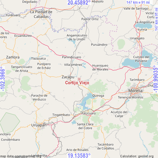
Cortijo Viejo GPS coordinates[2]
19° 47' 55.5" North, 101° 41' 36.492" West
| Map corner | latitude | longitude |
|---|---|---|
| Upper-left | 20.45892°, | -102.3966° |
| Center: | 19.79875°, | -101.69347° |
| Lower-right: | 19.13583°, | -100.99035° |
| Map W x H: | 147.1×147.1 km | = 91.4×91.4mi |
| max Lat: | 32.7° ⇑47.3% North |
| Cortijo Viejo: | 19.79875° |
| min Lat: | ⇓52.7% South 14.53588° |
| min Long | Cortijo Viejo | max Long |
| -117.105° | -101.69347° | -86.73105° |
| W 21.1%⇐ | ⇒78.9% E |
Elevation
Elevation of Cortijo Viejo is 1997 m = 6552 ft, and this is 743.3 m = 2439 ft above average elevation for this country.
| Max E: |
3497 m = 11473 ft | 26.7% |
| Cortijo Viejo | 1997 m 6552 ft | |
| Avg. | 1253.7 m = 4113 ft | |
Min E: |
-1 m = -3 ft | 73.3% |
See also: Mexico elevation on elevation.city.
Geographical zone
Cortijo Viejo is located in North Torrid zone (between Equator and Tropic of Cancer). Distance of this Northern Tropic circle is 404.5 km =251.3 mi to North.| Distance of | km | miles | from Cortijo Viejo |
|---|---|---|---|
| North Pole | 7805.6 | 4850.2 | to North |
| Arctic Circle | 5199.8 | 3231 | to North |
| Tropic Cancer | 404.5 | 251.3 | to North |
| Equator | 2201.4 | 1367.9 | to South |


Nearby cities:
15 places around Cortijo Viejo: (largest is in red/bold)
• Bellas Fuentes
2.9 km =1.8 mi,  30°
30°
• Cantabria
5.7 km =3.5 mi,  322°
322°
• Comanjá
5.8 km =3.6 mi,  177°
177°
• Cortijo Nuevo
1.9 km =1.2 mi,  204°
204°
• David Franco Reyes
5.8 km =3.6 mi,  215°
215°
• Matugeo
10.9 km =6.8 mi,  131°
131°
• Morelos
7.7 km =4.8 mi,  256°
256°
• Naranja de Tapia
7.3 km =4.5 mi,  250°
250°
• San Antonio Tariácuri
10.9 km =6.8 mi,  328°
328°
• Santiago Azajo
10.3 km =6.4 mi, 175°
• Tarejero
3.3 km =2.1 mi,  314°
314°
• Tiríndaro
6.1 km =3.8 mi,  239°
239°
• Tungüitiro
8.8 km =5.5 mi,  99°
99°
• Zacapu
10.3 km =6.4 mi,  284°
284°
• Zacapú
10.4 km =6.5 mi, 279°
Sources, notices
• [Note1] Compared only with cities in Mexico existing in our database
• [Src1] Map data: © OpenStreetMap contributors (CC-BY-SA)
• [Src2] Other city data from geonames.org with taken over terms of usage.
• [Src3] Geographical zone / Annual Mean Temperature by Robert A. Rohde @ Wikipedia
