Tengüecho geodata
Tengüecho (State of Mexico) is a populated place; located in Mexico in America/Mexico_City (GMT-6) time zone. With population of 1,028 people, there are 8476 cities with bigger population in this country. Compared to other cities in Mexico, 53.7% of cities are located further ↓South; 83.2% of cities are located further →East and 81.9% of cities have lower elevation than Tengüecho. Note1


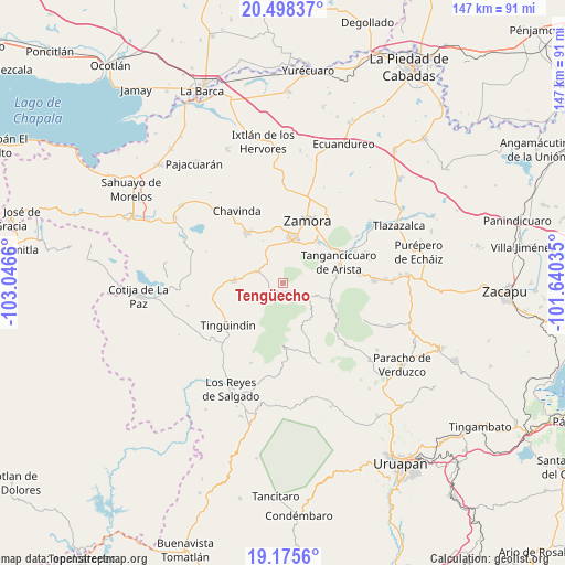
Tengüecho GPS coordinates[2]
19° 50' 18.096" North, 102° 20' 36.492" West
| Map corner | latitude | longitude |
|---|---|---|
| Upper-left | 20.49837°, | -103.0466° |
| Center: | 19.83836°, | -102.34347° |
| Lower-right: | 19.1756°, | -101.64035° |
| Map W x H: | 147.1×147.1 km | = 91.4×91.4mi |
| max Lat: | 32.7° ⇑46.3% North |
| Tengüecho: | 19.83836° |
| min Lat: | ⇓53.7% South 14.53588° |
| min Long | Tengüecho | max Long |
| -117.105° | -102.34347° | -86.73105° |
| W 16.8%⇐ | ⇒83.2% E |
Elevation
Elevation of Tengüecho is 2186 m = 7172 ft, and this is 932.3 m = 3059 ft above average elevation for this country.
| Max E: |
3497 m = 11473 ft | 18.1% |
| Tengüecho | 2186 m 7172 ft | |
| Avg. | 1253.7 m = 4113 ft | |
Min E: |
-1 m = -3 ft | 81.9% |
See also: Mexico elevation on elevation.city.
Geographical zone
Tengüecho is located in North Torrid zone (between Equator and Tropic of Cancer). Distance of this Northern Tropic circle is 400.1 km =248.6 mi to North.| Distance of | km | miles | from Tengüecho |
|---|---|---|---|
| North Pole | 7801.2 | 4847.4 | to North |
| Arctic Circle | 5195.4 | 3228.3 | to North |
| Tropic Cancer | 400.1 | 248.6 | to North |
| Equator | 2205.8 | 1370.6 | to South |


Nearby cities:
15 places around Tengüecho: (largest is in red/bold)
• Canindo
15.4 km =9.6 mi,  42°
42°
• Colonia las Malvinas (Colonia Antorcha)
13.1 km =8.1 mi,  70°
70°
• J. Jesús Díaz Tzirio
9.8 km =6.1 mi,  215°
215°
• Jacona de Plancarte
13.2 km =8.2 mi,  16°
16°
• La Cantera
7.4 km =4.6 mi,  292°
292°
• La Tinaja
14.1 km =8.8 mi,  206°
206°
• Ocumicho
13.6 km =8.5 mi,  110°
110°
• Rancho Nuevo (Joyas del Pedregal)
14.5 km =9 mi,  355°
355°
• San Benito
14.8 km =9.2 mi,  171°
171°
• San Isidro
12 km =7.5 mi,  156°
156°
• San José de Gracia (San José Ocumicho)
12.3 km =7.6 mi,  98°
98°
• Tamándaro
13.8 km =8.6 mi,  26°
26°
• Tangancícuaro de Arista
15.3 km =9.5 mi, 69°
• Tarécuato
12.7 km =7.9 mi,  272°
272°
• Urengüitiro (San Martín)
10.7 km =6.6 mi, 157°
Sources, notices
• [Note1] Compared only with cities in Mexico existing in our database
• [Src1] Map data: © OpenStreetMap contributors (CC-BY-SA)
• [Src2] Other city data from geonames.org with taken over terms of usage.
• [Src3] Geographical zone / Annual Mean Temperature by Robert A. Rohde @ Wikipedia
