La Tinaja geodata
La Tinaja (Michoacán) is a populated place; located in Mexico in America/Mexico_City (GMT-6) time zone. With population of 581 people, there are 14753 cities with bigger population in this country. Compared to other cities in Mexico, 51% of cities are located further ↓South; 83.5% of cities are located further →East and 79.2% of cities have lower elevation than La Tinaja. Note1


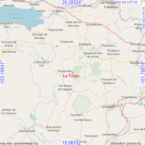
La Tinaja GPS coordinates[2]
19° 43' 29.1" North, 102° 24' 11.808" West
| Map corner | latitude | longitude |
|---|---|---|
| Upper-left | 20.38524°, | -103.10641° |
| Center: | 19.72475°, | -102.40328° |
| Lower-right: | 19.06152°, | -101.70016° |
| Map W x H: | 147.2×147.2 km | = 91.5×91.5mi |
| max Lat: | 32.7° ⇑49% North |
| La Tinaja: | 19.72475° |
| min Lat: | ⇓51% South 14.53588° |
| min Long | La Tinaja | max Long |
| -117.105° | -102.40328° | -86.73105° |
| W 16.5%⇐ | ⇒83.5% E |
Elevation
Elevation of La Tinaja is 2121 m = 6959 ft, and this is 867.3 m = 2845 ft above average elevation for this country.
| Max E: |
3497 m = 11473 ft | 20.8% |
| La Tinaja | 2121 m 6959 ft | |
| Avg. | 1253.7 m = 4113 ft | |
Min E: |
-1 m = -3 ft | 79.2% |
See also: Mexico elevation on elevation.city.
Geographical zone
La Tinaja is located in North Torrid zone (between Equator and Tropic of Cancer). Distance of this Northern Tropic circle is 412.7 km =256.4 mi to North.| Distance of | km | miles | from La Tinaja |
|---|---|---|---|
| North Pole | 7813.9 | 4855.3 | to North |
| Arctic Circle | 5208 | 3236.1 | to North |
| Tropic Cancer | 412.7 | 256.4 | to North |
| Equator | 2193.2 | 1362.8 | to South |


Nearby cities:
15 places around La Tinaja: (largest is in red/bold)
• Atapán
8.5 km =5.3 mi,  195°
195°
• Chaniro (Xhaniro)
4 km =2.5 mi,  238°
238°
• Cherato
11.9 km =7.4 mi,  153°
153°
• J. Jesús Díaz Tzirio
4.7 km =2.9 mi,  7°
7°
• La Higuerita (Colonia San Rafael)
14.5 km =9 mi,  215°
215°
• La Zarzamora
2.7 km =1.7 mi, 203°
• Pamatácuaro
7 km =4.3 mi,  121°
121°
• San Benito
8.8 km =5.5 mi,  102°
102°
• San Isidro
11.2 km =7 mi,  81°
81°
• Santa Clara de Valladares
13.4 km =8.3 mi, 223°
• Tengüecho
14.1 km =8.8 mi,  26°
26°
• Tingüindín
8.3 km =5.2 mi,  281°
281°
• Tocumbo
12.8 km =8 mi,  258°
258°
• Urengüitiro (San Martín)
10.8 km =6.7 mi,  74°
74°
• Zicuicho
10 km =6.2 mi,  133°
133°
Sources, notices
• [Note1] Compared only with cities in Mexico existing in our database
• [Src1] Map data: © OpenStreetMap contributors (CC-BY-SA)
• [Src2] Other city data from geonames.org with taken over terms of usage.
• [Src3] Geographical zone / Annual Mean Temperature by Robert A. Rohde @ Wikipedia
