Taretán geodata
Taretán (Michoacán) is a populated place; located in Mexico in America/Mexico_City (GMT-6) time zone. With population of 6,440 people, there are 1453 cities with bigger population in this country. Compared to other cities in Mexico, 58% of cities are located further ↑North; 80.4% of cities are located further →East and 56.4% of cities have higher elevation than Taretán. Note1


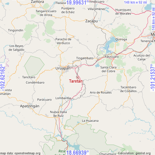
Taretán GPS coordinates[2]
19° 20' 3.12" North, 101° 55' 6.564" West
| Map corner | latitude | longitude |
|---|---|---|
| Upper-left | 19.99631°, | -102.62162° |
| Center: | 19.3342°, | -101.91849° |
| Lower-right: | 18.66939°, | -101.21537° |
| Map W x H: | 147.5×147.5 km | = 91.7×91.7mi |
| max Lat: | 32.7° ⇑58% North |
| Taretán: | 19.3342° |
| min Lat: | ⇓42% South 14.53588° |
| min Long | Taretán | max Long |
| -117.105° | -101.91849° | -86.73105° |
| W 19.6%⇐ | ⇒80.4% E |
Elevation
Elevation of Taretán is 1145 m = 3757 ft, and this is 108.7 m = 357 ft below average elevation for this country.
| Max E: |
3497 m = 11473 ft | 56.4% |
| Avg. | 1253.7 m = 4113 ft | |
| Taretán | 1145 m = 3757 ft | |
Min E: |
-1 m = -3 ft | 43.6% |
See also: Mexico elevation on elevation.city.
Geographical zone
Taretán is located in North Torrid zone (between Equator and Tropic of Cancer). Distance of this Northern Tropic circle is 456.2 km =283.5 mi to North.| Distance of | km | miles | from Taretán |
|---|---|---|---|
| North Pole | 7857.3 | 4882.3 | to North |
| Arctic Circle | 5251.4 | 3263.1 | to North |
| Tropic Cancer | 456.2 | 283.5 | to North |
| Equator | 2149.8 | 1335.8 | to South |


Nearby cities:
15 places around Taretán: (largest is in red/bold)
• Caltzontzín
13.6 km =8.5 mi,  316°
316°
• Caracha
11.2 km =7 mi,  358°
358°
• El Arroyo Colorado
14.5 km =9 mi,  276°
276°
• El Sabino
7.3 km =4.5 mi,  230°
230°
• Emiliano Zapata
1.8 km =1.1 mi, 282°
• La Florida
5.9 km =3.7 mi,  109°
109°
• La Purísima
3.9 km =2.4 mi,  137°
137°
• Los Cajones
13.9 km =8.6 mi,  177°
177°
• Patuán
6.5 km =4 mi,  1°
1°
• San Andrés Coru
15 km =9.3 mi,  349°
349°
• San Vicente
10 km =6.2 mi,  130°
130°
• Santa Rosa (Santa Bárbara)
13.5 km =8.4 mi,  293°
293°
• Tahuejo
4.6 km =2.9 mi,  248°
248°
• Tomendán
6.6 km =4.1 mi, 112°
• Zirimícuaro
9.2 km =5.7 mi,  332°
332°
Sources, notices
• [Note1] Compared only with cities in Mexico existing in our database
• [Src1] Map data: © OpenStreetMap contributors (CC-BY-SA)
• [Src2] Other city data from geonames.org with taken over terms of usage.
• [Src3] Geographical zone / Annual Mean Temperature by Robert A. Rohde @ Wikipedia
