Los Cajones geodata
Los Cajones (Michoacán) is a populated place; located in Mexico in America/Mexico_City (GMT-6) time zone. With population of 1,029 people, there are 8467 cities with bigger population in this country. Compared to other cities in Mexico, 60.9% of cities are located further ↑North; 80.4% of cities are located further →East and 68.4% of cities have higher elevation than Los Cajones. Note1


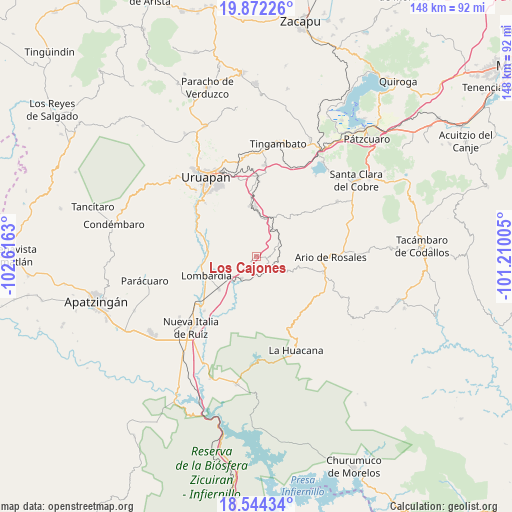
Los Cajones GPS coordinates[2]
19° 12' 34.704" North, 101° 54' 47.412" West
| Map corner | latitude | longitude |
|---|---|---|
| Upper-left | 19.87226°, | -102.6163° |
| Center: | 19.20964°, | -101.91317° |
| Lower-right: | 18.54434°, | -101.21005° |
| Map W x H: | 147.7×147.7 km | = 91.8×91.8mi |
| max Lat: | 32.7° ⇑60.9% North |
| Los Cajones: | 19.20964° |
| min Lat: | ⇓39.1% South 14.53588° |
| min Long | Los Cajones | max Long |
| -117.105° | -101.91317° | -86.73105° |
| W 19.6%⇐ | ⇒80.4% E |
Elevation
Elevation of Los Cajones is 501 m = 1644 ft, and this is 752.7 m = 2469 ft below average elevation for this country.
| Max E: |
3497 m = 11473 ft | 68.4% |
| Avg. | 1253.7 m = 4113 ft | |
| Los Cajones | 501 m = 1644 ft | |
Min E: |
-1 m = -3 ft | 31.6% |
See also: Mexico elevation on elevation.city.
Geographical zone
Los Cajones is located in North Torrid zone (between Equator and Tropic of Cancer). Distance of this Northern Tropic circle is 470 km =292 mi to North.| Distance of | km | miles | from Los Cajones |
|---|---|---|---|
| North Pole | 7871.2 | 4890.9 | to North |
| Arctic Circle | 5265.3 | 3271.7 | to North |
| Tropic Cancer | 470 | 292 | to North |
| Equator | 2135.9 | 1327.2 | to South |


Nearby cities:
15 places around Los Cajones: (largest is in red/bold)
• Charapendo
17.1 km =10.6 mi,  290°
290°
• El Sabino
11 km =6.8 mi,  326°
326°
• Emiliano Zapata
14.4 km =8.9 mi,  350°
350°
• La Florida
12.9 km =8 mi,  22°
22°
• La Ibérica (La Gotera)
5 km =3.1 mi,  183°
183°
• La Purísima
11.1 km =6.9 mi,  10°
10°
• Lombardía
15.6 km =9.7 mi,  248°
248°
• Los Otates
10.1 km =6.3 mi,  115°
115°
• Nuevo Urecho
6.8 km =4.2 mi,  135°
135°
• San Vicente
10.2 km =6.3 mi,  43°
43°
• Santa Casilda
7.6 km =4.7 mi,  213°
213°
• Tahuejo
13.1 km =8.1 mi,  338°
338°
• Taretán
13.9 km =8.6 mi,  357°
357°
• Tomendán
12.6 km =7.8 mi,  26°
26°
• Villa Eréndira
4.5 km =2.8 mi,  149°
149°
Sources, notices
• [Note1] Compared only with cities in Mexico existing in our database
• [Src1] Map data: © OpenStreetMap contributors (CC-BY-SA)
• [Src2] Other city data from geonames.org with taken over terms of usage.
• [Src3] Geographical zone / Annual Mean Temperature by Robert A. Rohde @ Wikipedia
