San Andrés Coru geodata
San Andrés Coru (Michoacán) is a populated place; located in Mexico in America/Mexico_City (GMT-6) time zone. With population of 2,223 people, there are 3947 cities with bigger population in this country. Compared to other cities in Mexico, 54.8% of cities are located further ↑North; 80.6% of cities are located further →East and 57.6% of cities have lower elevation than San Andrés Coru. Note1


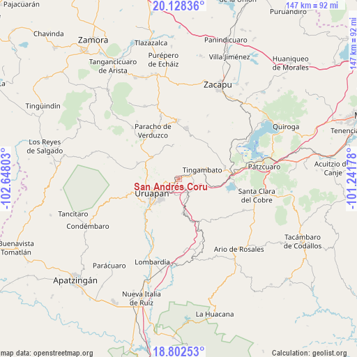
San Andrés Coru GPS coordinates[2]
19° 28' 0.48" North, 101° 56' 41.64" West
| Map corner | latitude | longitude |
|---|---|---|
| Upper-left | 20.12836°, | -102.64803° |
| Center: | 19.4668°, | -101.9449° |
| Lower-right: | 18.80253°, | -101.24178° |
| Map W x H: | 147.4×147.4 km | = 91.6×91.6mi |
| max Lat: | 32.7° ⇑54.8% North |
| San Andrés Coru: | 19.4668° |
| min Lat: | ⇓45.2% South 14.53588° |
| min Long | San Andrés Cor | max Long |
| -117.105° | -101.9449° | -86.73105° |
| W 19.4%⇐ | ⇒80.6% E |
Elevation
Elevation of San Andrés Coru is 1681 m = 5515 ft, and this is 427.3 m = 1402 ft above average elevation for this country.
| Max E: |
3497 m = 11473 ft | 42.4% |
| San Andrés Coru | 1681 m 5515 ft | |
| Avg. | 1253.7 m = 4113 ft | |
Min E: |
-1 m = -3 ft | 57.6% |
See also: Mexico elevation on elevation.city.
Geographical zone
San Andrés Coru is located in North Torrid zone (between Equator and Tropic of Cancer). Distance of this Northern Tropic circle is 441.4 km =274.3 mi to North.| Distance of | km | miles | from San Andrés Coru |
|---|---|---|---|
| North Pole | 7842.6 | 4873.2 | to North |
| Arctic Circle | 5236.7 | 3253.9 | to North |
| Tropic Cancer | 441.4 | 274.3 | to North |
| Equator | 2164.5 | 1345 | to South |


Nearby cities:
15 places around San Andrés Coru: (largest is in red/bold)
• Arantepacua
14.6 km =9.1 mi,  350°
350°
• Caltzontzín
8.1 km =5 mi,  233°
233°
• Capácuaro
14.4 km =8.9 mi,  308°
308°
• Caracha
4.3 km =2.7 mi,  145°
145°
• Comachuén
12.4 km =7.7 mi,  20°
20°
• Emiliano Zapata
14.4 km =8.9 mi,  176°
176°
• La Basília
12.7 km =7.9 mi,  267°
267°
• La Escondida
9.7 km =6 mi,  88°
88°
• Patuán
8.8 km =5.5 mi,  160°
160°
• Santa Rosa (Santa Bárbara)
13.3 km =8.3 mi, 225°
• Tingambato
10.3 km =6.4 mi,  68°
68°
• Toreo Bajo (El Toreo Bajo)
6.7 km =4.2 mi,  248°
248°
• Turícuaro
11.6 km =7.2 mi,  3°
3°
• Uruapan
13.2 km =8.2 mi,  242°
242°
• Zirimícuaro
6.7 km =4.2 mi,  192°
192°
Sources, notices
• [Note1] Compared only with cities in Mexico existing in our database
• [Src1] Map data: © OpenStreetMap contributors (CC-BY-SA)
• [Src2] Other city data from geonames.org with taken over terms of usage.
• [Src3] Geographical zone / Annual Mean Temperature by Robert A. Rohde @ Wikipedia
