Caracha geodata
Caracha (Michoacán) is a populated place; located in Mexico in America/Mexico_City (GMT-6) time zone. With population of 930 people, there are 9378 cities with bigger population in this country. Compared to other cities in Mexico, 55.4% of cities are located further ↑North; 80.5% of cities are located further →East and 50.2% of cities have higher elevation than Caracha. Note1


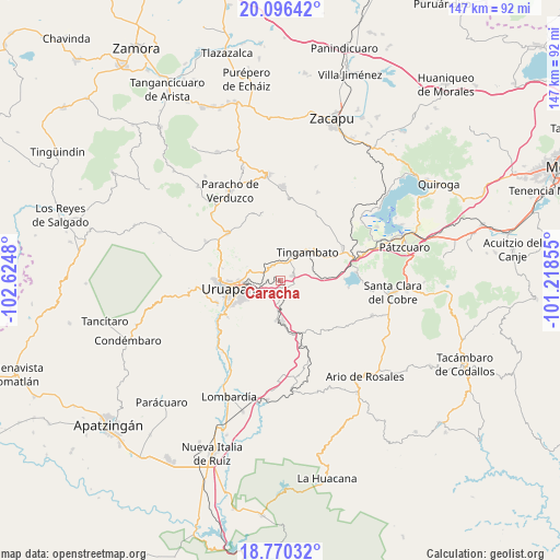
Caracha GPS coordinates[2]
19° 26' 4.992" North, 101° 55' 18.012" West
| Map corner | latitude | longitude |
|---|---|---|
| Upper-left | 20.09642°, | -102.6248° |
| Center: | 19.43472°, | -101.92167° |
| Lower-right: | 18.77032°, | -101.21855° |
| Map W x H: | 147.4×147.5 km | = 91.6×91.7mi |
| max Lat: | 32.7° ⇑55.4% North |
| Caracha: | 19.43472° |
| min Lat: | ⇓44.6% South 14.53588° |
| min Long | Caracha | max Long |
| -117.105° | -101.92167° | -86.73105° |
| W 19.5%⇐ | ⇒80.5% E |
Elevation
Elevation of Caracha is 1423 m = 4669 ft, and this is 169.3 m = 555 ft above average elevation for this country.
| Max E: |
3497 m = 11473 ft | 50.2% |
| Caracha | 1423 m 4669 ft | |
| Avg. | 1253.7 m = 4113 ft | |
Min E: |
-1 m = -3 ft | 49.8% |
See also: Mexico elevation on elevation.city.
Geographical zone
Caracha is located in North Torrid zone (between Equator and Tropic of Cancer). Distance of this Northern Tropic circle is 445 km =276.5 mi to North.| Distance of | km | miles | from Caracha |
|---|---|---|---|
| North Pole | 7846.1 | 4875.3 | to North |
| Arctic Circle | 5240.2 | 3256.1 | to North |
| Tropic Cancer | 445 | 276.5 | to North |
| Equator | 2160.9 | 1342.7 | to South |


Nearby cities:
15 places around Caracha: (largest is in red/bold)
• Caltzontzín
9 km =5.6 mi,  261°
261°
• Emiliano Zapata
10.9 km =6.8 mi,  187°
187°
• La Escondida
8.2 km =5.1 mi,  62°
62°
• La Florida
14.4 km =8.9 mi,  155°
155°
• La Purísima
14.4 km =8.9 mi,  168°
168°
• Patuán
4.7 km =2.9 mi, 173°
• San Andrés Coru
4.3 km =2.7 mi,  325°
325°
• Santa Rosa (Santa Bárbara)
13.3 km =8.3 mi,  244°
244°
• Tahuejo
13.5 km =8.4 mi,  197°
197°
• Taretán
11.2 km =7 mi,  178°
178°
• Tingambato
10.3 km =6.4 mi,  44°
44°
• Tomendán
15.1 km =9.4 mi,  154°
154°
• Toreo Bajo (El Toreo Bajo)
8.7 km =5.4 mi,  277°
277°
• Uruapan
14.4 km =8.9 mi, 259°
• Zirimícuaro
4.9 km =3 mi,  232°
232°
Sources, notices
• [Note1] Compared only with cities in Mexico existing in our database
• [Src1] Map data: © OpenStreetMap contributors (CC-BY-SA)
• [Src2] Other city data from geonames.org with taken over terms of usage.
• [Src3] Geographical zone / Annual Mean Temperature by Robert A. Rohde @ Wikipedia
