Santa Rosa Jauregui geodata
Santa Rosa Jauregui (Querétaro) is a populated place; located in Mexico in America/Mexico_City (GMT-6) time zone. With population of 18,508 people, there are 529 cities with bigger population in this country. Compared to other cities in Mexico, 72.4% of cities are located further ↓South; 69% of cities are located further →East and 71.8% of cities have lower elevation than Santa Rosa Jauregui. Note1


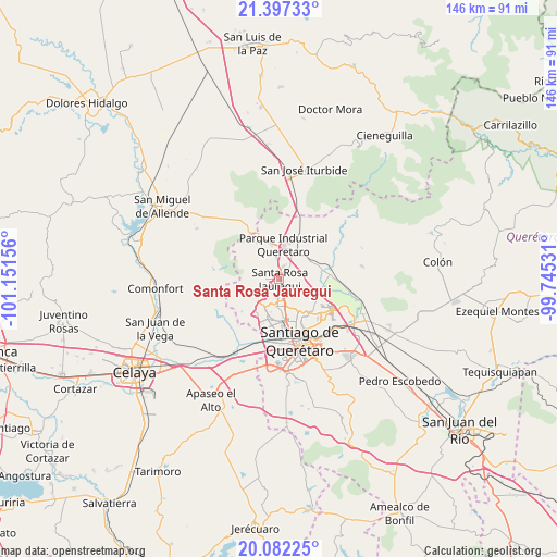
Santa Rosa Jauregui GPS coordinates[2]
20° 44' 28.392" North, 100° 26' 54.348" West
| Map corner | latitude | longitude |
|---|---|---|
| Upper-left | 21.39733°, | -101.15156° |
| Center: | 20.74122°, | -100.44843° |
| Lower-right: | 20.08225°, | -99.74531° |
| Map W x H: | 146.2×146.2 km | = 90.8×90.8mi |
| max Lat: | 32.7° ⇑27.6% North |
| Santa Rosa Jauregui: | 20.74122° |
| min Lat: | ⇓72.4% South 14.53588° |
| min Long | Santa Rosa Jaur | max Long |
| -117.105° | -100.44843° | -86.73105° |
| W 31%⇐ | ⇒69% E |
Elevation
Elevation of Santa Rosa Jauregui is 1963 m = 6440 ft, and this is 709.3 m = 2327 ft above average elevation for this country.
| Max E: |
3497 m = 11473 ft | 28.2% |
| Santa Rosa Jauregui | 1963 m 6440 ft | |
| Avg. | 1253.7 m = 4113 ft | |
Min E: |
-1 m = -3 ft | 71.8% |
See also: Mexico elevation on elevation.city.
Geographical zone
Santa Rosa Jauregui is located in North Torrid zone (between Equator and Tropic of Cancer). Distance of this Northern Tropic circle is 299.7 km =186.2 mi to North.| Distance of | km | miles | from Santa Rosa Jauregui |
|---|---|---|---|
| North Pole | 7700.9 | 4785.1 | to North |
| Arctic Circle | 5095 | 3165.9 | to North |
| Tropic Cancer | 299.7 | 186.2 | to North |
| Equator | 2306.2 | 1433 | to South |


Nearby cities:
15 places around Santa Rosa Jauregui: (largest is in red/bold)
• Acequia Blanca
3.1 km =1.9 mi,  218°
218°
• Casa Blanca
6 km =3.7 mi,  281°
281°
• Cerro Colorado (El Colorado)
5.7 km =3.5 mi,  293°
293°
• Corea
6.7 km =4.2 mi,  358°
358°
• El Nabo
6.2 km =3.9 mi,  212°
212°
• Hacienda Santa Rosa [Fraccionamiento]
3 km =1.9 mi,  21°
21°
• Juriquilla
3.3 km =2.1 mi,  193°
193°
• La Solana
5.6 km =3.5 mi,  93°
93°
• Montenegro
3.2 km =2 mi,  39°
39°
• Pie de Gallo
6.6 km =4.1 mi,  315°
315°
• Rancho Largo
4.4 km =2.7 mi,  168°
168°
• San Isidro Buenavista
5.3 km =3.3 mi, 359°
• San José Buenavista
4.1 km =2.5 mi,  100°
100°
• San Miguelito
5.7 km =3.5 mi,  265°
265°
• Santa Catarina
4 km =2.5 mi,  354°
354°
Sources, notices
• [Note1] Compared only with cities in Mexico existing in our database
• [Src1] Map data: © OpenStreetMap contributors (CC-BY-SA)
• [Src2] Other city data from geonames.org with taken over terms of usage.
• [Src3] Geographical zone / Annual Mean Temperature by Robert A. Rohde @ Wikipedia
