Santa Fe del Río geodata
Santa Fe del Río (Michoacán) is a populated place; located in Mexico in America/Mexico_City (GMT-6) time zone. With population of 1,342 people, there are 6480 cities with bigger population in this country. Compared to other cities in Mexico, 61.4% of cities are located further ↓South; 79.9% of cities are located further →East and 58% of cities have lower elevation than Santa Fe del Río. Note1


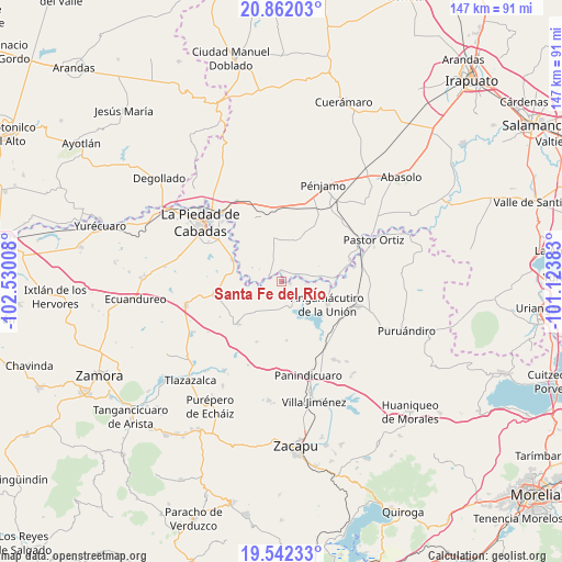
Santa Fe del Río GPS coordinates[2]
20° 12' 12.888" North, 101° 49' 37.02" West
| Map corner | latitude | longitude |
|---|---|---|
| Upper-left | 20.86203°, | -102.53008° |
| Center: | 20.20358°, | -101.82695° |
| Lower-right: | 19.54233°, | -101.12383° |
| Map W x H: | 146.7×146.7 km | = 91.2×91.2mi |
| max Lat: | 32.7° ⇑38.6% North |
| Santa Fe del Río: | 20.20358° |
| min Lat: | ⇓61.4% South 14.53588° |
| min Long | Santa Fe del R� | max Long |
| -117.105° | -101.82695° | -86.73105° |
| W 20.1%⇐ | ⇒79.9% E |
Elevation
Elevation of Santa Fe del Río is 1691 m = 5548 ft, and this is 437.3 m = 1435 ft above average elevation for this country.
| Max E: |
3497 m = 11473 ft | 42% |
| Santa Fe del Río | 1691 m 5548 ft | |
| Avg. | 1253.7 m = 4113 ft | |
Min E: |
-1 m = -3 ft | 58% |
See also: Mexico elevation on elevation.city.
Geographical zone
Santa Fe del Río is located in North Torrid zone (between Equator and Tropic of Cancer). Distance of this Northern Tropic circle is 359.5 km =223.4 mi to North.| Distance of | km | miles | from Santa Fe del Río |
|---|---|---|---|
| North Pole | 7760.6 | 4822.2 | to North |
| Arctic Circle | 5154.7 | 3203 | to North |
| Tropic Cancer | 359.5 | 223.4 | to North |
| Equator | 2246.4 | 1395.8 | to South |


Nearby cities:
15 places around Santa Fe del Río: (largest is in red/bold)
• Ansihuacuaro
2.2 km =1.4 mi,  101°
101°
• Castillo de Villaseñor
8.9 km =5.5 mi,  347°
347°
• Cerritos Blancos
8.6 km =5.3 mi,  295°
295°
• Corrales de Rábago
3.6 km =2.2 mi,  289°
289°
• Cruces de Rojas
8.6 km =5.3 mi,  308°
308°
• Cuevas de Morales
10.1 km =6.3 mi, 350°
• El Infiernillo
7.5 km =4.7 mi, 347°
• El Mármol
10 km =6.2 mi,  81°
81°
• Guándaro
5.1 km =3.2 mi,  255°
255°
• La Luz
10.4 km =6.5 mi,  223°
223°
• Patambarillo
8.3 km =5.2 mi,  200°
200°
• Potrerillos del Río
3.8 km =2.4 mi,  61°
61°
• San Ignacio de Álvarez
7.2 km =4.5 mi,  359°
359°
• San José de Rábago
8.3 km =5.2 mi,  238°
238°
• Veredas
6.5 km =4 mi,  337°
337°
Sources, notices
• [Note1] Compared only with cities in Mexico existing in our database
• [Src1] Map data: © OpenStreetMap contributors (CC-BY-SA)
• [Src2] Other city data from geonames.org with taken over terms of usage.
• [Src3] Geographical zone / Annual Mean Temperature by Robert A. Rohde @ Wikipedia
