Guándaro geodata
Guándaro (Michoacán) is a populated place; located in Mexico in America/Mexico_City (GMT-6) time zone. With population of 1,143 people, there are 7600 cities with bigger population in this country. Compared to other cities in Mexico, 61.2% of cities are located further ↓South; 80.2% of cities are located further →East and 58.3% of cities have lower elevation than Guándaro. Note1


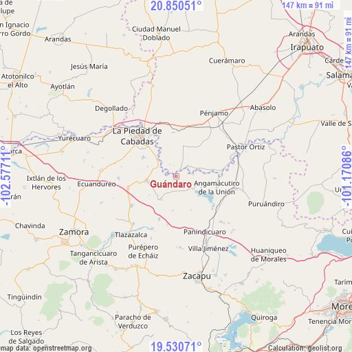
Guándaro GPS coordinates[2]
20° 11' 31.236" North, 101° 52' 26.328" West
| Map corner | latitude | longitude |
|---|---|---|
| Upper-left | 20.85051°, | -102.57711° |
| Center: | 20.19201°, | -101.87398° |
| Lower-right: | 19.53071°, | -101.17086° |
| Map W x H: | 146.7×146.8 km | = 91.2×91.2mi |
| max Lat: | 32.7° ⇑38.8% North |
| Guándaro: | 20.19201° |
| min Lat: | ⇓61.2% South 14.53588° |
| min Long | Guándaro | max Long |
| -117.105° | -101.87398° | -86.73105° |
| W 19.8%⇐ | ⇒80.2% E |
Elevation
Elevation of Guándaro is 1695 m = 5561 ft, and this is 441.3 m = 1448 ft above average elevation for this country.
| Max E: |
3497 m = 11473 ft | 41.7% |
| Guándaro | 1695 m 5561 ft | |
| Avg. | 1253.7 m = 4113 ft | |
Min E: |
-1 m = -3 ft | 58.3% |
See also: Mexico elevation on elevation.city.
Geographical zone
Guándaro is located in North Torrid zone (between Equator and Tropic of Cancer). Distance of this Northern Tropic circle is 360.8 km =224.2 mi to North.| Distance of | km | miles | from Guándaro |
|---|---|---|---|
| North Pole | 7761.9 | 4823 | to North |
| Arctic Circle | 5156 | 3203.8 | to North |
| Tropic Cancer | 360.8 | 224.2 | to North |
| Equator | 2245.1 | 1395 | to South |


Nearby cities:
15 places around Guándaro: (largest is in red/bold)
• Ansihuacuaro
7.1 km =4.4 mi,  82°
82°
• Cerritos Blancos
5.8 km =3.6 mi,  330°
330°
• Corrales de Rábago
2.9 km =1.8 mi,  31°
31°
• Cruces de Rojas
7 km =4.3 mi,  344°
344°
• El Colorado
7 km =4.3 mi,  248°
248°
• El Infiernillo
9.2 km =5.7 mi,  20°
20°
• El Palmito
7.8 km =4.8 mi,  286°
286°
• La Luz
6.7 km =4.2 mi,  199°
199°
• La Tepuza
5.4 km =3.4 mi,  261°
261°
• Patambarillo
6.8 km =4.2 mi,  162°
162°
• Potrerillos del Río
8.8 km =5.5 mi,  69°
69°
• San Ignacio de Álvarez
9.8 km =6.1 mi, 29°
• San José de Rábago
3.8 km =2.4 mi,  214°
214°
• Santa Fe del Río
5.1 km =3.2 mi, 75°
• Veredas
7.7 km =4.8 mi, 18°
Sources, notices
• [Note1] Compared only with cities in Mexico existing in our database
• [Src1] Map data: © OpenStreetMap contributors (CC-BY-SA)
• [Src2] Other city data from geonames.org with taken over terms of usage.
• [Src3] Geographical zone / Annual Mean Temperature by Robert A. Rohde @ Wikipedia
