Veredas geodata
Veredas (Guanajuato) is a populated place; located in Mexico in America/Mexico_City (GMT-6) time zone. With population of 556 people, there are 15345 cities with bigger population in this country. Compared to other cities in Mexico, 62.6% of cities are located further ↓South; 80% of cities are located further →East and 57.6% of cities have lower elevation than Veredas. Note1


Veredas GPS coordinates[2]
20° 15' 26.64" North, 101° 51' 3.528" West
| Map corner | latitude | longitude |
|---|---|---|
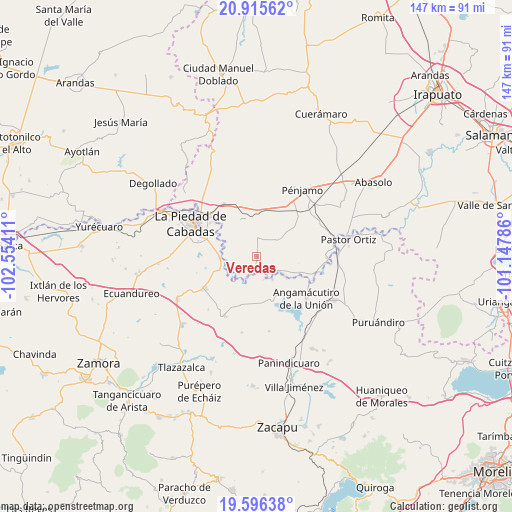
| Upper-left | 20.91562°, | -102.55411° |
| Center: | 20.2574°, | -101.85098° |
| Lower-right: | 19.59638°, | -101.14786° |
| Map W x H: | 146.7×146.7 km | = 91.2×91.2mi |
| max Lat: | 32.7° ⇑37.4% North |
| Veredas: | 20.2574° |
| min Lat: | ⇓62.6% South 14.53588° |
| min Long | Veredas | max Long |
| -117.105° | -101.85098° | -86.73105° |
| W 20%⇐ | ⇒80% E |
Elevation
Elevation of Veredas is 1680 m = 5512 ft, and this is 426.3 m = 1399 ft above average elevation for this country.
| Max E: |
3497 m = 11473 ft | 42.4% |
| Veredas | 1680 m 5512 ft | |
| Avg. | 1253.7 m = 4113 ft | |
Min E: |
-1 m = -3 ft | 57.6% |
See also: Mexico elevation on elevation.city.
Geographical zone
Veredas is located in North Torrid zone (between Equator and Tropic of Cancer). Distance of this Northern Tropic circle is 353.5 km =219.7 mi to North.| Distance of | km | miles | from Veredas |
|---|---|---|---|
| North Pole | 7754.7 | 4818.5 | to North |
| Arctic Circle | 5148.8 | 3199.3 | to North |
| Tropic Cancer | 353.5 | 219.7 | to North |
| Equator | 2252.4 | 1399.6 | to South |


Nearby cities:
15 places around Veredas: (largest is in red/bold)
• Castillo de Villaseñor
2.8 km =1.7 mi,  13°
13°
• Cerritos Blancos
5.7 km =3.5 mi,  247°
247°
• Colorado de Herrera
6.9 km =4.3 mi, 5°
• Corrales de Rábago
4.9 km =3 mi,  190°
190°
• Cruces de Rojas
4.2 km =2.6 mi,  262°
262°
• Cuevas de Morales
4.1 km =2.5 mi, 11°
• El Infiernillo
1.6 km =1 mi,  33°
33°
• Guándaro
7.7 km =4.8 mi,  198°
198°
• La Lobera
6.8 km =4.2 mi,  296°
296°
• Mezquite de Luna
6.2 km =3.9 mi,  315°
315°
• Palo Verde
7.4 km =4.6 mi,  1°
1°
• Potrerillos del Río
7.2 km =4.5 mi,  125°
125°
• San Ignacio de Álvarez
2.7 km =1.7 mi,  62°
62°
• Santa Fe del Río
6.5 km =4 mi,  157°
157°
• Tacubaya
7.6 km =4.7 mi,  49°
49°
Sources, notices
• [Note1] Compared only with cities in Mexico existing in our database
• [Src1] Map data: © OpenStreetMap contributors (CC-BY-SA)
• [Src2] Other city data from geonames.org with taken over terms of usage.
• [Src3] Geographical zone / Annual Mean Temperature by Robert A. Rohde @ Wikipedia
