San Simón geodata
San Simón (State of Mexico) is a populated place; located in Mexico in America/Mexico_City (GMT-6) time zone. With population of 997 people, there are 8740 cities with bigger population in this country. Compared to other cities in Mexico, 69.6% of cities are located further ↑North; 66.2% of cities are located further →East and 50.7% of cities have lower elevation than San Simón. Note1


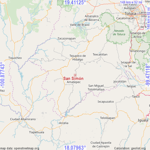
San Simón GPS coordinates[2]
18° 44' 48.3" North, 100° 10' 27.48" West
| Map corner | latitude | longitude |
|---|---|---|
| Upper-left | 19.41125°, | -100.87743° |
| Center: | 18.74675°, | -100.1743° |
| Lower-right: | 18.07963°, | -99.47118° |
| Map W x H: | 148.1×148.1 km | = 92×92mi |
| max Lat: | 32.7° ⇑69.6% North |
| San Simón: | 18.74675° |
| min Lat: | ⇓30.4% South 14.53588° |
| min Long | San Simón | max Long |
| -117.105° | -100.1743° | -86.73105° |
| W 33.8%⇐ | ⇒66.2% E |
Elevation
Elevation of San Simón is 1471 m = 4826 ft, and this is 217.3 m = 713 ft above average elevation for this country.
| Max E: |
3497 m = 11473 ft | 49.3% |
| San Simón | 1471 m 4826 ft | |
| Avg. | 1253.7 m = 4113 ft | |
Min E: |
-1 m = -3 ft | 50.7% |
See also: Mexico elevation on elevation.city.
Geographical zone
San Simón is located in North Torrid zone (between Equator and Tropic of Cancer). Distance of this Northern Tropic circle is 521.5 km =324 mi to North.| Distance of | km | miles | from San Simón |
|---|---|---|---|
| North Pole | 7922.6 | 4922.9 | to North |
| Arctic Circle | 5316.7 | 3303.6 | to North |
| Tropic Cancer | 521.5 | 324 | to North |
| Equator | 2084.4 | 1295.2 | to South |


Nearby cities:
15 places around San Simón: (largest is in red/bold)
• Amatepec
7.3 km =4.5 mi,  189°
189°
• Cerro del Campo
13.1 km =8.1 mi,  224°
224°
• El Rancho
13.2 km =8.2 mi,  236°
236°
• La Labor de Zaragoza
16 km =9.9 mi,  29°
29°
• Llano Grande
12.2 km =7.6 mi,  38°
38°
• Rincón de Aguirre
17.4 km =10.8 mi,  13°
13°
• Rincón de Jaimes
16.9 km =10.5 mi,  3°
3°
• San Francisco de Asís
17.4 km =10.8 mi, 219°
• San Isidro Xochitla
17.2 km =10.7 mi,  72°
72°
• San Juan Tetitlán
15.5 km =9.6 mi, 189°
• San Mateo (San Mateo Guayatenco)
12.9 km =8 mi,  168°
168°
• San Miguel Ixtapan
7.1 km =4.4 mi,  18°
18°
• Santa María
17.6 km =10.9 mi,  156°
156°
• Tejupilco de Hidalgo
17.7 km =11 mi, 7°
• Tlatlaya
14.8 km =9.2 mi, 193°
Sources, notices
• [Note1] Compared only with cities in Mexico existing in our database
• [Src1] Map data: © OpenStreetMap contributors (CC-BY-SA)
• [Src2] Other city data from geonames.org with taken over terms of usage.
• [Src3] Geographical zone / Annual Mean Temperature by Robert A. Rohde @ Wikipedia
