Llano Grande geodata
Llano Grande (State of Mexico) is a populated place; located in Mexico in America/Mexico_City (GMT-6) time zone. With population of 639 people, there are 13559 cities with bigger population in this country. Compared to other cities in Mexico, 68.2% of cities are located further ↑North; 65.2% of cities are located further →East and 54.7% of cities have higher elevation than Llano Grande. Note1


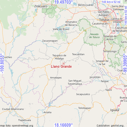
Llano Grande GPS coordinates[2]
18° 49' 58.368" North, 100° 6' 7.812" West
| Map corner | latitude | longitude |
|---|---|---|
| Upper-left | 19.49703°, | -100.8053° |
| Center: | 18.83288°, | -100.10217° |
| Lower-right: | 18.16609°, | -99.39905° |
| Map W x H: | 148×148 km | = 92×92mi |
| max Lat: | 32.7° ⇑68.2% North |
| Llano Grande: | 18.83288° |
| min Lat: | ⇓31.8% South 14.53588° |
| min Long | Llano Grande | max Long |
| -117.105° | -100.10217° | -86.73105° |
| W 34.8%⇐ | ⇒65.2% E |
Elevation
Elevation of Llano Grande is 1210 m = 3970 ft, and this is 43.7 m = 143 ft below average elevation for this country.
| Max E: |
3497 m = 11473 ft | 54.7% |
| Avg. | 1253.7 m = 4113 ft | |
| Llano Grande | 1210 m = 3970 ft | |
Min E: |
-1 m = -3 ft | 45.3% |
See also: Mexico elevation on elevation.city.
Geographical zone
Llano Grande is located in North Torrid zone (between Equator and Tropic of Cancer). Distance of this Northern Tropic circle is 511.9 km =318.1 mi to North.| Distance of | km | miles | from Llano Grande |
|---|---|---|---|
| North Pole | 7913 | 4916.9 | to North |
| Arctic Circle | 5307.2 | 3297.7 | to North |
| Tropic Cancer | 511.9 | 318.1 | to North |
| Equator | 2094 | 1301.2 | to South |


Nearby cities:
15 places around Llano Grande: (largest is in red/bold)
• Colonia Buenavista Primera Sección
10.7 km =6.6 mi,  327°
327°
• Jalpan (Jalpan San Simón)
12.3 km =7.6 mi, 327°
• La Labor de Zaragoza
4.3 km =2.7 mi,  5°
5°
• Pantoja
10.1 km =6.3 mi,  61°
61°
• Rincón de Aguirre
8.2 km =5.1 mi, 333°
• Rincón de Jaimes
9.9 km =6.2 mi,  317°
317°
• Rincón de Ugarte
11.7 km =7.3 mi, 334°
• Rincón del Carmen
8 km =5 mi,  345°
345°
• San Andrés Ocotepec
9.8 km =6.1 mi,  36°
36°
• San Isidro Xochitla
9.8 km =6.1 mi,  116°
116°
• San Miguel Ixtapan
6 km =3.7 mi,  241°
241°
• San Simón
12.2 km =7.6 mi,  218°
218°
• Santa Cruz
12.5 km =7.8 mi,  89°
89°
• Sultepec
14.6 km =9.1 mi,  78°
78°
• Tejupilco de Hidalgo
9.6 km =6 mi, 326°
Sources, notices
• [Note1] Compared only with cities in Mexico existing in our database
• [Src1] Map data: © OpenStreetMap contributors (CC-BY-SA)
• [Src2] Other city data from geonames.org with taken over terms of usage.
• [Src3] Geographical zone / Annual Mean Temperature by Robert A. Rohde @ Wikipedia
