El Rancho geodata
El Rancho (State of Mexico) is a populated place; located in Mexico in America/Mexico_City (GMT-6) time zone. With population of 512 people, there are 16417 cities with bigger population in this country. Compared to other cities in Mexico, 70.4% of cities are located further ↑North; 67.2% of cities are located further →East and 62.1% of cities have higher elevation than El Rancho. Note1


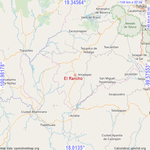
El Rancho GPS coordinates[2]
18° 40' 51.168" North, 100° 16' 43.14" West
| Map corner | latitude | longitude |
|---|---|---|
| Upper-left | 19.34564°, | -100.98178° |
| Center: | 18.68088°, | -100.27865° |
| Lower-right: | 18.0135°, | -99.57553° |
| Map W x H: | 148.1×148.1 km | = 92×92mi |
| max Lat: | 32.7° ⇑70.4% North |
| El Rancho: | 18.68088° |
| min Lat: | ⇓29.6% South 14.53588° |
| min Long | El Rancho | max Long |
| -117.105° | -100.27865° | -86.73105° |
| W 32.8%⇐ | ⇒67.2% E |
Elevation
Elevation of El Rancho is 876 m = 2874 ft, and this is 377.7 m = 1239 ft below average elevation for this country.
| Max E: |
3497 m = 11473 ft | 62.1% |
| Avg. | 1253.7 m = 4113 ft | |
| El Rancho | 876 m = 2874 ft | |
Min E: |
-1 m = -3 ft | 37.9% |
See also: Mexico elevation on elevation.city.
Geographical zone
El Rancho is located in North Torrid zone (between Equator and Tropic of Cancer). Distance of this Northern Tropic circle is 528.8 km =328.6 mi to North.| Distance of | km | miles | from El Rancho |
|---|---|---|---|
| North Pole | 7929.9 | 4927.4 | to North |
| Arctic Circle | 5324.1 | 3308.2 | to North |
| Tropic Cancer | 528.8 | 328.6 | to North |
| Equator | 2077.1 | 1290.6 | to South |


Nearby cities:
15 places around El Rancho: (largest is in red/bold)
• Amatepec
9.8 km =6.1 mi,  89°
89°
• Bejucos
19.1 km =11.9 mi,  304°
304°
• Cerro del Campo
2.6 km =1.6 mi,  138°
138°
• Mayaltepec
14.6 km =9.1 mi,  221°
221°
• Palmar Chico
9.6 km =6 mi,  280°
280°
• Palmar Grande
17.7 km =11 mi,  231°
231°
• San Francisco de Asís
6 km =3.7 mi,  181°
181°
• San Juan Tetitlán
11.6 km =7.2 mi,  133°
133°
• San Mateo (San Mateo Guayatenco)
14.5 km =9 mi,  111°
111°
• San Miguel Ixtapan
19.3 km =12 mi,  43°
43°
• San Pedro Limón
11.4 km =7.1 mi,  195°
195°
• San Simón
13.2 km =8.2 mi,  56°
56°
• Santa Ana Zicatecoyan
13.6 km =8.5 mi,  153°
153°
• Tlacocuspan
8.1 km =5 mi,  211°
211°
• Tlatlaya
10.2 km =6.3 mi, 133°
Sources, notices
• [Note1] Compared only with cities in Mexico existing in our database
• [Src1] Map data: © OpenStreetMap contributors (CC-BY-SA)
• [Src2] Other city data from geonames.org with taken over terms of usage.
• [Src3] Geographical zone / Annual Mean Temperature by Robert A. Rohde @ Wikipedia
