San Pablo geodata
San Pablo (Guanajuato) is a populated place; located in Mexico in America/Mexico_City (GMT-6) time zone. With population of 780 people, there are 11196 cities with bigger population in this country. Compared to other cities in Mexico, 61.5% of cities are located further ↓South; 69.8% of cities are located further →East and 77.5% of cities have lower elevation than San Pablo. Note1


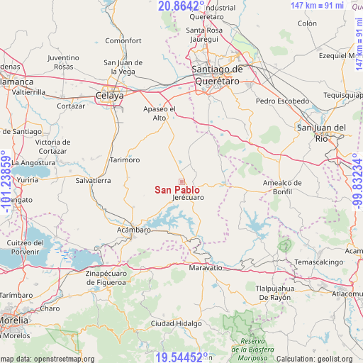
San Pablo GPS coordinates[2]
20° 12' 20.736" North, 100° 32' 7.656" West
| Map corner | latitude | longitude |
|---|---|---|
| Upper-left | 20.8642°, | -101.23859° |
| Center: | 20.20576°, | -100.53546° |
| Lower-right: | 19.54452°, | -99.83234° |
| Map W x H: | 146.7×146.7 km | = 91.2×91.2mi |
| max Lat: | 32.7° ⇑38.5% North |
| San Pablo: | 20.20576° |
| min Lat: | ⇓61.5% South 14.53588° |
| min Long | San Pablo | max Long |
| -117.105° | -100.53546° | -86.73105° |
| W 30.2%⇐ | ⇒69.8% E |
Elevation
Elevation of San Pablo is 2078 m = 6818 ft, and this is 824.3 m = 2704 ft above average elevation for this country.
| Max E: |
3497 m = 11473 ft | 22.5% |
| San Pablo | 2078 m 6818 ft | |
| Avg. | 1253.7 m = 4113 ft | |
Min E: |
-1 m = -3 ft | 77.5% |
See also: Mexico elevation on elevation.city.
Geographical zone
San Pablo is located in North Torrid zone (between Equator and Tropic of Cancer). Distance of this Northern Tropic circle is 359.2 km =223.2 mi to North.| Distance of | km | miles | from San Pablo |
|---|---|---|---|
| North Pole | 7760.4 | 4822.1 | to North |
| Arctic Circle | 5154.5 | 3202.9 | to North |
| Tropic Cancer | 359.2 | 223.2 | to North |
| Equator | 2246.7 | 1396 | to South |


Nearby cities:
15 places around San Pablo: (largest is in red/bold)
• Candelas
15 km =9.3 mi,  37°
37°
• El Fresno
8.8 km =5.5 mi,  31°
31°
• El Tepozán
14.9 km =9.3 mi,  15°
15°
• El Terrero
8.5 km =5.3 mi,  208°
208°
• Estanzuela de Razo
12.5 km =7.8 mi,  176°
176°
• Estanzuela de Romero
4 km =2.5 mi,  125°
125°
• Jerécuaro
6.3 km =3.9 mi,  153°
153°
• Jiménez
13.3 km =8.3 mi,  354°
354°
• La Huerta
13.9 km =8.6 mi,  94°
94°
• La Purisima del Zapóte
7.7 km =4.8 mi, 182°
• Ojo de Agua de Mendoza
5.7 km =3.5 mi,  218°
218°
• Piedras de Lumbre
8.4 km =5.2 mi,  306°
306°
• Salto de Peña
14 km =8.7 mi,  323°
323°
• San Lucas
9.9 km =6.2 mi, 349°
• San Pedro de los Agustinos
4.2 km =2.6 mi,  302°
302°
Sources, notices
• [Note1] Compared only with cities in Mexico existing in our database
• [Src1] Map data: © OpenStreetMap contributors (CC-BY-SA)
• [Src2] Other city data from geonames.org with taken over terms of usage.
• [Src3] Geographical zone / Annual Mean Temperature by Robert A. Rohde @ Wikipedia
