Candelas geodata
Candelas (Guanajuato) is a populated place; located in Mexico in America/Mexico_City (GMT-6) time zone. With population of 917 people, there are 9514 cities with bigger population in this country. Compared to other cities in Mexico, 63.8% of cities are located further ↓South; 69% of cities are located further →East and 87.5% of cities have lower elevation than Candelas. Note1


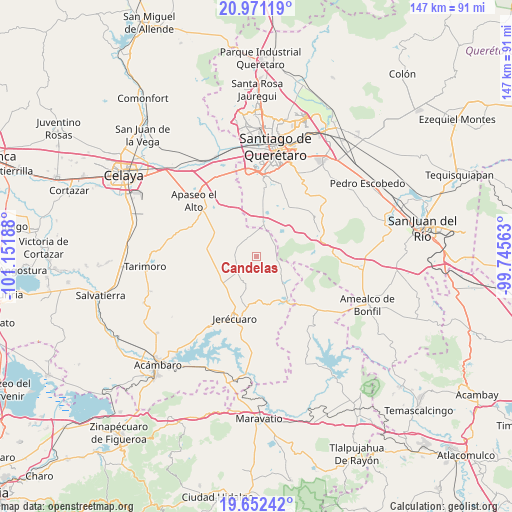
Candelas GPS coordinates[2]
20° 18' 47.556" North, 100° 26' 55.5" West
| Map corner | latitude | longitude |
|---|---|---|
| Upper-left | 20.97119°, | -101.15188° |
| Center: | 20.31321°, | -100.44875° |
| Lower-right: | 19.65242°, | -99.74563° |
| Map W x H: | 146.6×146.6 km | = 91.1×91.1mi |
| max Lat: | 32.7° ⇑36.2% North |
| Candelas: | 20.31321° |
| min Lat: | ⇓63.8% South 14.53588° |
| min Long | Candelas | max Long |
| -117.105° | -100.44875° | -86.73105° |
| W 31%⇐ | ⇒69% E |
Elevation
Elevation of Candelas is 2324 m = 7625 ft, and this is 1070.3 m = 3511 ft above average elevation for this country.
| Max E: |
3497 m = 11473 ft | 12.5% |
| Candelas | 2324 m 7625 ft | |
| Avg. | 1253.7 m = 4113 ft | |
Min E: |
-1 m = -3 ft | 87.5% |
See also: Mexico elevation on elevation.city.
Geographical zone
Candelas is located in North Torrid zone (between Equator and Tropic of Cancer). Distance of this Northern Tropic circle is 347.3 km =215.8 mi to North.| Distance of | km | miles | from Candelas |
|---|---|---|---|
| North Pole | 7748.4 | 4814.6 | to North |
| Arctic Circle | 5142.6 | 3195.5 | to North |
| Tropic Cancer | 347.3 | 215.8 | to North |
| Equator | 2258.6 | 1403.4 | to South |


Nearby cities:
15 places around Candelas: (largest is in red/bold)
• Belén
9.8 km =6.1 mi,  308°
308°
• Bravo
10 km =6.2 mi,  14°
14°
• Buenavista
11.2 km =7 mi,  42°
42°
• Ceja de Bravo
9.2 km =5.7 mi, 38°
• El Fresno
6.3 km =3.9 mi,  225°
225°
• El Jaral
10.4 km =6.5 mi,  356°
356°
• El Sauz de Cebolletas
9.5 km =5.9 mi,  126°
126°
• El Tepozán
5.7 km =3.5 mi,  295°
295°
• Huitrón
11.4 km =7.1 mi,  53°
53°
• Jiménez
10.5 km =6.5 mi,  277°
277°
• Presa de Bravo
13 km =8.1 mi, 10°
• San Isidro de Gamboa
12.2 km =7.6 mi,  318°
318°
• San José Tepuzas
8.9 km =5.5 mi,  59°
59°
• San Lucas
11 km =6.8 mi,  258°
258°
• Santa Cruz de Gamboa
11 km =6.8 mi, 320°
Sources, notices
• [Note1] Compared only with cities in Mexico existing in our database
• [Src1] Map data: © OpenStreetMap contributors (CC-BY-SA)
• [Src2] Other city data from geonames.org with taken over terms of usage.
• [Src3] Geographical zone / Annual Mean Temperature by Robert A. Rohde @ Wikipedia
