Cabo San Lucas geodata
Cabo San Lucas (Baja California Sur) is a populated place; located in Mexico in America/Mazatlan (GMT-7) time zone. With population of 68,463 people, there are 174 cities with bigger population in this country. Compared to other cities in Mexico, 87.8% of cities are located further ↓South; 98% of cities are located further →East and 96.3% of cities have higher elevation than Cabo San Lucas. Note1


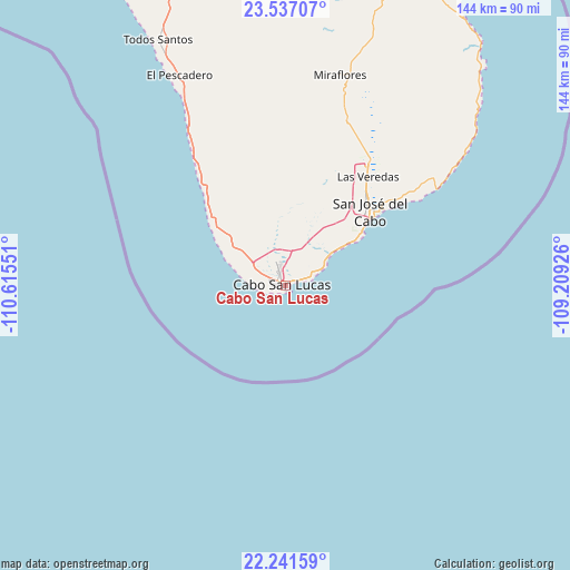
Cabo San Lucas GPS coordinates[2]
22° 53' 27.168" North, 109° 54' 44.568" West
| Map corner | latitude | longitude |
|---|---|---|
| Upper-left | 23.53707°, | -110.61551° |
| Center: | 22.89088°, | -109.91238° |
| Lower-right: | 22.24159°, | -109.20926° |
| Map W x H: | 144×144 km | = 89.5×89.5mi |
| max Lat: | 32.7° ⇑12.2% North |
| Cabo San Lucas: | 22.89088° |
| min Lat: | ⇓87.8% South 14.53588° |
| min Long | Cabo San Lucas | max Long |
| -117.105° | -109.91238° | -86.73105° |
| W 2%⇐ | ⇒98% E |
Elevation
Elevation of Cabo San Lucas is 11 m = 36 ft, and this is 1242.7 m = 4077 ft below average elevation for this country.
| Max E: |
3497 m = 11473 ft | 96.3% |
| Avg. | 1253.7 m = 4113 ft | |
| Cabo San Lucas | 11 m = 36 ft | |
Min E: |
-1 m = -3 ft | 3.7% |
See also: Cabo San Lucas elevation on elevation.city.
Geographical zone
Cabo San Lucas is located in North Torrid zone (between Equator and Tropic of Cancer). Distance of this Northern Tropic circle is 60.7 km =37.7 mi to North.| Distance of | km | miles | from Cabo San Lucas |
|---|---|---|---|
| North Pole | 7461.8 | 4636.5 | to North |
| Arctic Circle | 4855.9 | 3017.3 | to North |
| Tropic Cancer | 60.7 | 37.7 | to North |
| Equator | 2545.2 | 1581.5 | to South |


Nearby cities:
15 places around Cabo San Lucas: (largest is in red/bold)
• Colonia del Sol
2.8 km =1.7 mi,  329°
329°
• El Campamento
76.4 km =47.5 mi,  18°
18°
• El Pescadero
58.8 km =36.5 mi, 333°
• El Tezal
2.6 km =1.6 mi,  55°
55°
• Fraccionamiento la Ballena Segunda Etapa
33 km =20.5 mi,  34°
34°
• La Playa
31.5 km =19.6 mi,  52°
52°
• La Rivera
85.1 km =52.9 mi, 23°
• Las Palmas
5.9 km =3.7 mi, 328°
• Las Veredas
35.7 km =22.2 mi,  36°
36°
• Miraflores
55.1 km =34.2 mi,  14°
14°
• San José del Cabo
28.8 km =17.9 mi, 49°
• Santa Anita
38.7 km =24 mi, 33°
• Santa Catarina
35.5 km =22.1 mi, 40°
• Santiago
68.4 km =42.5 mi, 17°
• Todos Santos
69.5 km =43.2 mi, 332°
Sources, notices
• [Note1] Compared only with cities in Mexico existing in our database
• [Src1] Map data: © OpenStreetMap contributors (CC-BY-SA)
• [Src2] Other city data from geonames.org with taken over terms of usage.
• [Src3] Geographical zone / Annual Mean Temperature by Robert A. Rohde @ Wikipedia
