Las Palmas geodata
Las Palmas (Baja California Sur) is a populated place; located in Mexico in America/Mazatlan (GMT-7) time zone. With population of 11,562 people, there are 829 cities with bigger population in this country. Compared to other cities in Mexico, 87.9% of cities are located further ↓South; 98.1% of cities are located further →East and 77.1% of cities have higher elevation than Las Palmas. Note1


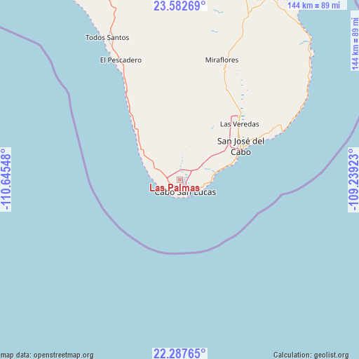
Las Palmas GPS coordinates[2]
22° 56' 12.192" North, 109° 56' 32.46" West
| Map corner | latitude | longitude |
|---|---|---|
| Upper-left | 23.58269°, | -110.64548° |
| Center: | 22.93672°, | -109.94235° |
| Lower-right: | 22.28765°, | -109.23923° |
| Map W x H: | 144×144 km | = 89.5×89.5mi |
| max Lat: | 32.7° ⇑12.1% North |
| Las Palmas: | 22.93672° |
| min Lat: | ⇓87.9% South 14.53588° |
| min Long | Las Palmas | max Long |
| -117.105° | -109.94235° | -86.73105° |
| W 1.9%⇐ | ⇒98.1% E |
Elevation
Elevation of Las Palmas is 150 m = 492 ft, and this is 1103.7 m = 3621 ft below average elevation for this country.
| Max E: |
3497 m = 11473 ft | 77.1% |
| Avg. | 1253.7 m = 4113 ft | |
| Las Palmas | 150 m = 492 ft | |
Min E: |
-1 m = -3 ft | 22.9% |
See also: Mexico elevation on elevation.city.
Geographical zone
Las Palmas is located in North Torrid zone (between Equator and Tropic of Cancer). Distance of this Northern Tropic circle is 55.6 km =34.5 mi to North.| Distance of | km | miles | from Las Palmas |
|---|---|---|---|
| North Pole | 7456.7 | 4633.4 | to North |
| Arctic Circle | 4850.8 | 3014.1 | to North |
| Tropic Cancer | 55.6 | 34.5 | to North |
| Equator | 2550.3 | 1584.7 | to South |


Nearby cities:
15 places around Las Palmas: (largest is in red/bold)
• Cabo San Lucas
5.9 km =3.7 mi,  148°
148°
• Colonia del Sol
3.1 km =1.9 mi, 148°
• El Campamento
72.6 km =45.1 mi,  21°
21°
• El Pescadero
52.8 km =32.8 mi,  334°
334°
• El Tezal
6.3 km =3.9 mi,  124°
124°
• Fraccionamiento la Ballena Segunda Etapa
31 km =19.3 mi,  44°
44°
• La Playa
31.4 km =19.5 mi,  63°
63°
• La Rivera
81.7 km =50.8 mi,  26°
26°
• Las Veredas
33.9 km =21.1 mi,  45°
45°
• Miraflores
51.1 km =31.8 mi, 19°
• San José del Cabo
28.5 km =17.7 mi, 61°
• Santa Anita
36.6 km =22.7 mi, 42°
• Santa Catarina
34 km =21.1 mi, 49°
• Santiago
64.6 km =40.1 mi, 21°
• Todos Santos
63.6 km =39.5 mi, 333°
Sources, notices
• [Note1] Compared only with cities in Mexico existing in our database
• [Src1] Map data: © OpenStreetMap contributors (CC-BY-SA)
• [Src2] Other city data from geonames.org with taken over terms of usage.
• [Src3] Geographical zone / Annual Mean Temperature by Robert A. Rohde @ Wikipedia
