San Cayetano geodata
San Cayetano (Nayarit) is a populated place; located in Mexico in America/Mazatlan (GMT-7) time zone. With population of 892 people, there are 9779 cities with bigger population in this country. Compared to other cities in Mexico, 86.5% of cities are located further ↓South; 93.5% of cities are located further →East and 99.1% of cities have higher elevation than San Cayetano. Note1


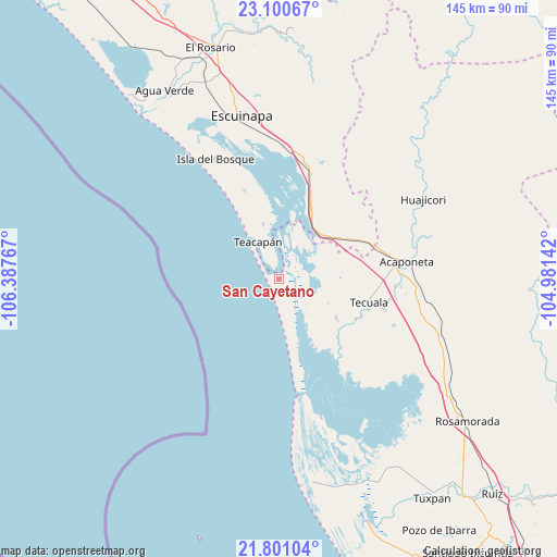
San Cayetano GPS coordinates[2]
22° 27' 8.568" North, 105° 41' 4.344" West
| Map corner | latitude | longitude |
|---|---|---|
| Upper-left | 23.10067°, | -106.38767° |
| Center: | 22.45238°, | -105.68454° |
| Lower-right: | 21.80104°, | -104.98142° |
| Map W x H: | 144.5×144.5 km | = 89.8×89.8mi |
| max Lat: | 32.7° ⇑13.5% North |
| San Cayetano: | 22.45238° |
| min Lat: | ⇓86.5% South 14.53588° |
| min Long | San Cayetano | max Long |
| -117.105° | -105.68454° | -86.73105° |
| W 6.5%⇐ | ⇒93.5% E |
Elevation
Elevation of San Cayetano is 6 m = 20 ft, and this is 1247.7 m = 4094 ft below average elevation for this country.
| Max E: |
3497 m = 11473 ft | 99.1% |
| Avg. | 1253.7 m = 4113 ft | |
| San Cayetano | 6 m = 20 ft | |
Min E: |
-1 m = -3 ft | 0.9% |
See also: Mexico elevation on elevation.city.
Geographical zone
San Cayetano is located in North Torrid zone (between Equator and Tropic of Cancer). Distance of this Northern Tropic circle is 109.4 km =68 mi to North.| Distance of | km | miles | from San Cayetano |
|---|---|---|---|
| North Pole | 7510.6 | 4666.9 | to North |
| Arctic Circle | 4904.7 | 3047.6 | to North |
| Tropic Cancer | 109.4 | 68 | to North |
| Equator | 2496.5 | 1551.3 | to South |


Nearby cities:
15 places around San Cayetano: (largest is in red/bold)
• Atotonilco
21.9 km =13.6 mi,  109°
109°
• Cristo Rey
14.9 km =9.3 mi,  344°
344°
• El Aguaje
18.2 km =11.3 mi,  71°
71°
• El Filo
24.5 km =15.2 mi, 109°
• El Tigre
23 km =14.3 mi,  77°
77°
• Milpas Viejas
23.6 km =14.7 mi, 114°
• Novillero
8.3 km =5.2 mi,  163°
163°
• Ojo de Agua de Palmillas
20.4 km =12.7 mi,  23°
23°
• Pajaritos
16 km =9.9 mi,  88°
88°
• Palmito del Verde
24.6 km =15.3 mi, 338°
• Paso Hondo
14.2 km =8.8 mi,  116°
116°
• Quimichis
18.1 km =11.2 mi, 124°
• Río Viejo
16.7 km =10.4 mi, 113°
• Teacapan
11.1 km =6.9 mi,  331°
331°
• Tecuala
24 km =14.9 mi,  104°
104°
Sources, notices
• [Note1] Compared only with cities in Mexico existing in our database
• [Src1] Map data: © OpenStreetMap contributors (CC-BY-SA)
• [Src2] Other city data from geonames.org with taken over terms of usage.
• [Src3] Geographical zone / Annual Mean Temperature by Robert A. Rohde @ Wikipedia
