San Carlos geodata
San Carlos (Coahuila) is a populated place; located in Mexico in America/Monterrey (GMT-6) time zone. With population of 3,126 people, there are 2889 cities with bigger population in this country. Compared to other cities in Mexico, 98% of cities are located further ↓South; 72.7% of cities are located further →East and 72% of cities have higher elevation than San Carlos. Note1


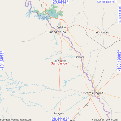
San Carlos GPS coordinates[2]
29° 1' 42.384" North, 100° 54' 7.812" West
| Map corner | latitude | longitude |
|---|---|---|
| Upper-left | 29.6414°, | -101.6053° |
| Center: | 29.02844°, | -100.90217° |
| Lower-right: | 28.41182°, | -100.19905° |
| Map W x H: | 136.7×136.7 km | = 84.9×84.9mi |
| max Lat: | 32.7° ⇑2% North |
| San Carlos: | 29.02844° |
| min Lat: | ⇓98% South 14.53588° |
| min Long | San Carlos | max Long |
| -117.105° | -100.90217° | -86.73105° |
| W 27.3%⇐ | ⇒72.7% E |
Elevation
Elevation of San Carlos is 330 m = 1083 ft, and this is 923.7 m = 3031 ft below average elevation for this country.
| Max E: |
3497 m = 11473 ft | 72% |
| Avg. | 1253.7 m = 4113 ft | |
| San Carlos | 330 m = 1083 ft | |
Min E: |
-1 m = -3 ft | 28% |
See also: Mexico elevation on elevation.city.
Geographical zone
San Carlos is located in North temperate zone (between Tropic of Cancer and the Arctic Circle). Distance of this Northern Tropic circle is 621.7 km =386.3 mi to South.| Distance of | km | miles | from San Carlos |
|---|---|---|---|
| North Pole | 6779.4 | 4212.5 | to North |
| Arctic Circle | 4173.5 | 2593.3 | to North |
| Tropic Cancer | 621.7 | 386.3 | to South |
| Equator | 3227.7 | 2005.6 | to South |


Nearby cities:
15 places around San Carlos: (largest is in red/bold)
• Allende
76.6 km =47.6 mi,  176°
176°
• Centro de Readaptación Social Piedras Negras
40.7 km =25.3 mi,  134°
134°
• Ciudad Acuña
33.1 km =20.6 mi,  351°
351°
• Colonia Venustiano Carranza
54.9 km =34.1 mi,  142°
142°
• Fraccionamiento Villa Real
48.4 km =30.1 mi, 140°
• Jiménez
22.2 km =13.8 mi,  78°
78°
• Los Álamos
74.8 km =46.5 mi, 183°
• Madero del Río
23 km =14.3 mi,  19°
19°
• Morelos
69.1 km =42.9 mi, 178°
• Nava
68.9 km =42.8 mi,  168°
168°
• Paso del Tío Pío
61.1 km =38 mi, 180°
• Piedras Negras
51.9 km =32.2 mi, 134°
• Río Bravo
79.6 km =49.5 mi, 181°
• Santa María
24.3 km =15.1 mi,  10°
10°
• Zaragoza
59.5 km =37 mi, 181°
Sources, notices
• [Note1] Compared only with cities in Mexico existing in our database
• [Src1] Map data: © OpenStreetMap contributors (CC-BY-SA)
• [Src2] Other city data from geonames.org with taken over terms of usage.
• [Src3] Geographical zone / Annual Mean Temperature by Robert A. Rohde @ Wikipedia
