Nava geodata
Nava (Coahuila) is a seat of a second-order administrative division; located in Mexico in America/Monterrey (GMT-6) time zone. With population of 22,192 people, there are 464 cities with bigger population in this country. Compared to other cities in Mexico, 97.7% of cities are located further ↓South; 71.6% of cities are located further →East and 72% of cities have higher elevation than Nava. Note1


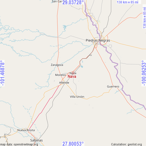
Nava GPS coordinates[2]
28° 25' 14.556" North, 100° 45' 56.34" West
| Map corner | latitude | longitude |
|---|---|---|
| Upper-left | 29.03728°, | -101.46878° |
| Center: | 28.42071°, | -100.76565° |
| Lower-right: | 27.80053°, | -100.06253° |
| Map W x H: | 137.5×137.5 km | = 85.4×85.4mi |
| max Lat: | 32.7° ⇑2.3% North |
| Nava: | 28.42071° |
| min Lat: | ⇓97.7% South 14.53588° |
| min Long | Nava | max Long |
| -117.105° | -100.76565° | -86.73105° |
| W 28.4%⇐ | ⇒71.6% E |
Elevation
Elevation of Nava is 329 m = 1079 ft, and this is 924.7 m = 3034 ft below average elevation for this country.
| Max E: |
3497 m = 11473 ft | 72% |
| Avg. | 1253.7 m = 4113 ft | |
| Nava | 329 m = 1079 ft | |
Min E: |
-1 m = -3 ft | 28% |
See also: Mexico elevation on elevation.city.
Geographical zone
Nava is located in North temperate zone (between Tropic of Cancer and the Arctic Circle). Distance of this Northern Tropic circle is 554.2 km =344.4 mi to South.| Distance of | km | miles | from Nava |
|---|---|---|---|
| North Pole | 6847 | 4254.5 | to North |
| Arctic Circle | 4241.1 | 2635.3 | to North |
| Tropic Cancer | 554.2 | 344.4 | to South |
| Equator | 3160.1 | 1963.6 | to South |


Nearby cities:
15 places around Nava: (largest is in red/bold)
• Allende
12.2 km =7.6 mi,  223°
223°
• Centro de Readaptación Social Piedras Negras
42.2 km =26.2 mi,  22°
22°
• Cloete
68.6 km =42.6 mi, 215°
• Colonia Venustiano Carranza
31.7 km =19.7 mi,  40°
40°
• Fraccionamiento Villa Real
35.2 km =21.9 mi,  30°
30°
• Guerrero
39.6 km =24.6 mi,  108°
108°
• Los Álamos
19 km =11.8 mi,  247°
247°
• Morelos
12.1 km =7.5 mi,  262°
262°
• Paso del Tío Pío
14.9 km =9.3 mi,  295°
295°
• Piedras Negras
39 km =24.2 mi, 37°
• Río Bravo
19.1 km =11.9 mi,  230°
230°
• San Carlos
68.9 km =42.8 mi,  348°
348°
• Villa Union
23.2 km =14.4 mi,  168°
168°
• Villa Unión
22.4 km =13.9 mi, 170°
• Zaragoza
17.3 km =10.7 mi, 297°
Sources, notices
• [Note1] Compared only with cities in Mexico existing in our database
• [Src1] Map data: © OpenStreetMap contributors (CC-BY-SA)
• [Src2] Other city data from geonames.org with taken over terms of usage.
• [Src3] Geographical zone / Annual Mean Temperature by Robert A. Rohde @ Wikipedia
