Zaragoza geodata
Zaragoza (Coahuila) is a seat of a second-order administrative division; located in Mexico in America/Monterrey (GMT-6) time zone. With population of 10,461 people, there are 910 cities with bigger population in this country. Compared to other cities in Mexico, 97.8% of cities are located further ↓South; 72.8% of cities are located further →East and 71.2% of cities have higher elevation than Zaragoza. Note1


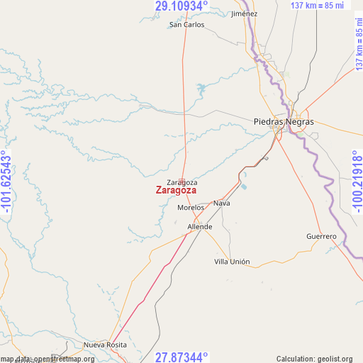
Zaragoza GPS coordinates[2]
28° 29' 35.52" North, 100° 55' 20.28" West
| Map corner | latitude | longitude |
|---|---|---|
| Upper-left | 29.10934°, | -101.62543° |
| Center: | 28.4932°, | -100.9223° |
| Lower-right: | 27.87344°, | -100.21918° |
| Map W x H: | 137.4×137.4 km | = 85.4×85.4mi |
| max Lat: | 32.7° ⇑2.2% North |
| Zaragoza: | 28.4932° |
| min Lat: | ⇓97.8% South 14.53588° |
| min Long | Zaragoza | max Long |
| -117.105° | -100.9223° | -86.73105° |
| W 27.2%⇐ | ⇒72.8% E |
Elevation
Elevation of Zaragoza is 362 m = 1188 ft, and this is 891.7 m = 2926 ft below average elevation for this country.
| Max E: |
3497 m = 11473 ft | 71.2% |
| Avg. | 1253.7 m = 4113 ft | |
| Zaragoza | 362 m = 1188 ft | |
Min E: |
-1 m = -3 ft | 28.8% |
See also: Mexico elevation on elevation.city.
Geographical zone
Zaragoza is located in North temperate zone (between Tropic of Cancer and the Arctic Circle). Distance of this Northern Tropic circle is 562.2 km =349.3 mi to South.| Distance of | km | miles | from Zaragoza |
|---|---|---|---|
| North Pole | 6838.9 | 4249.5 | to North |
| Arctic Circle | 4233 | 2630.3 | to North |
| Tropic Cancer | 562.2 | 349.3 | to South |
| Equator | 3168.1 | 1968.6 | to South |


Nearby cities:
15 places around Zaragoza: (largest is in red/bold)
• Allende
18.3 km =11.4 mi,  157°
157°
• Centro de Readaptación Social Piedras Negras
44 km =27.3 mi,  45°
45°
• Colonia Venustiano Carranza
39.2 km =24.4 mi,  65°
65°
• Fraccionamiento Villa Real
39.9 km =24.8 mi,  55°
55°
• Guerrero
56.8 km =35.3 mi,  111°
111°
• Los Álamos
15.4 km =9.6 mi,  188°
188°
• Morelos
10.2 km =6.3 mi, 161°
• Nava
17.3 km =10.7 mi,  117°
117°
• Nueva Rosita
68 km =42.3 mi,  205°
205°
• Paso del Tío Pío
2.5 km =1.6 mi,  131°
131°
• Piedras Negras
45.2 km =28.1 mi, 59°
• Río Bravo
20.1 km =12.5 mi,  178°
178°
• San Carlos
59.5 km =37 mi,  1°
1°
• Villa Union
36.7 km =22.8 mi,  146°
146°
• Villa Unión
35.7 km =22.2 mi, 147°
Sources, notices
• [Note1] Compared only with cities in Mexico existing in our database
• [Src1] Map data: © OpenStreetMap contributors (CC-BY-SA)
• [Src2] Other city data from geonames.org with taken over terms of usage.
• [Src3] Geographical zone / Annual Mean Temperature by Robert A. Rohde @ Wikipedia
