San Antonio la Labor geodata
San Antonio la Labor (Michoacán) is a populated place; located in Mexico in America/Mexico_City (GMT-6) time zone. With population of 1,128 people, there are 7689 cities with bigger population in this country. Compared to other cities in Mexico, 64.2% of cities are located further ↑North; 82.8% of cities are located further →East and 72.3% of cities have higher elevation than San Antonio la Labor. Note1


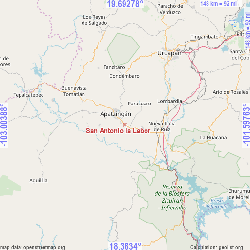
San Antonio la Labor GPS coordinates[2]
19° 1' 45.912" North, 102° 18' 2.7" West
| Map corner | latitude | longitude |
|---|---|---|
| Upper-left | 19.69278°, | -103.00388° |
| Center: | 19.02942°, | -102.30075° |
| Lower-right: | 18.3634°, | -101.59763° |
| Map W x H: | 147.8×147.8 km | = 91.8×91.8mi |
| max Lat: | 32.7° ⇑64.2% North |
| San Antonio la Labor: | 19.02942° |
| min Lat: | ⇓35.8% South 14.53588° |
| min Long | San Antonio la | max Long |
| -117.105° | -102.30075° | -86.73105° |
| W 17.2%⇐ | ⇒82.8% E |
Elevation
Elevation of San Antonio la Labor is 318 m = 1043 ft, and this is 935.7 m = 3070 ft below average elevation for this country.
| Max E: |
3497 m = 11473 ft | 72.3% |
| Avg. | 1253.7 m = 4113 ft | |
| San Antonio la Labor | 318 m = 1043 ft | |
Min E: |
-1 m = -3 ft | 27.7% |
See also: Mexico elevation on elevation.city.
Geographical zone
San Antonio la Labor is located in North Torrid zone (between Equator and Tropic of Cancer). Distance of this Northern Tropic circle is 490 km =304.5 mi to North.| Distance of | km | miles | from San Antonio la Labor |
|---|---|---|---|
| North Pole | 7891.2 | 4903.4 | to North |
| Arctic Circle | 5285.3 | 3284.1 | to North |
| Tropic Cancer | 490 | 304.5 | to North |
| Equator | 2115.9 | 1314.8 | to South |


Nearby cities:
15 places around San Antonio la Labor: (largest is in red/bold)
• Antúnez
10.3 km =6.4 mi,  99°
99°
• Antúnez (Morelos)
10.3 km =6.4 mi, 100°
• Apatzingán
8.9 km =5.5 mi,  318°
318°
• Buenos Aires
13.7 km =8.5 mi,  68°
68°
• Cancita
9.4 km =5.8 mi,  176°
176°
• Chiquihuitillo
5.1 km =3.2 mi,  243°
243°
• El Ceñidor
12 km =7.5 mi, 104°
• Fraccionamiento Girasoles
3 km =1.9 mi,  325°
325°
• La Huerta
7.9 km =4.9 mi,  10°
10°
• Las Yeguas
13.9 km =8.6 mi,  169°
169°
• Loma de los Hoyos
14.9 km =9.3 mi,  272°
272°
• Los Hornos
14.9 km =9.3 mi,  298°
298°
• Presa del Rosario
12.2 km =7.6 mi,  290°
290°
• Uspero
3.7 km =2.3 mi,  116°
116°
• Veinte de Noviembre
7 km =4.3 mi,  51°
51°
Sources, notices
• [Note1] Compared only with cities in Mexico existing in our database
• [Src1] Map data: © OpenStreetMap contributors (CC-BY-SA)
• [Src2] Other city data from geonames.org with taken over terms of usage.
• [Src3] Geographical zone / Annual Mean Temperature by Robert A. Rohde @ Wikipedia
