Antúnez geodata
Antúnez (Michoacán) is a populated place; located in Mexico in America/Mexico_City (GMT-6) time zone. With population of 8,591 people, there are 1110 cities with bigger population in this country. Compared to other cities in Mexico, 64.4% of cities are located further ↑North; 82% of cities are located further →East and 71% of cities have higher elevation than Antúnez. Note1


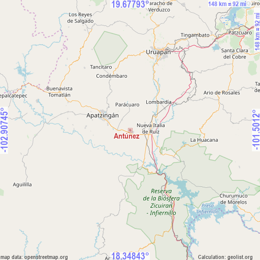
Antúnez GPS coordinates[2]
19° 0' 52.236" North, 102° 12' 15.552" West
| Map corner | latitude | longitude |
|---|---|---|
| Upper-left | 19.67793°, | -102.90745° |
| Center: | 19.01451°, | -102.20432° |
| Lower-right: | 18.34843°, | -101.5012° |
| Map W x H: | 147.8×147.8 km | = 91.8×91.8mi |
| max Lat: | 32.7° ⇑64.4% North |
| Antúnez: | 19.01451° |
| min Lat: | ⇓35.6% South 14.53588° |
| min Long | Antúnez | max Long |
| -117.105° | -102.20432° | -86.73105° |
| W 18%⇐ | ⇒82% E |
Elevation
Elevation of Antúnez is 371 m = 1217 ft, and this is 882.7 m = 2896 ft below average elevation for this country.
| Max E: |
3497 m = 11473 ft | 71% |
| Avg. | 1253.7 m = 4113 ft | |
| Antúnez | 371 m = 1217 ft | |
Min E: |
-1 m = -3 ft | 29% |
See also: Mexico elevation on elevation.city.
Geographical zone
Antúnez is located in North Torrid zone (between Equator and Tropic of Cancer). Distance of this Northern Tropic circle is 491.7 km =305.5 mi to North.| Distance of | km | miles | from Antúnez |
|---|---|---|---|
| North Pole | 7892.8 | 4904.4 | to North |
| Arctic Circle | 5287 | 3285.2 | to North |
| Tropic Cancer | 491.7 | 305.5 | to North |
| Equator | 2114.2 | 1313.7 | to South |


Nearby cities:
15 places around Antúnez: (largest is in red/bold)
• Antúnez (Morelos)
0.2 km =0.1 mi,  166°
166°
• Buenos Aires
7.2 km =4.5 mi,  20°
20°
• Cancita
12.3 km =7.6 mi,  231°
231°
• Cuatro Caminos
11 km =6.8 mi,  105°
105°
• El Ceñidor
2 km =1.2 mi,  131°
131°
• El Letrero
11.4 km =7.1 mi,  119°
119°
• Fraccionamiento Girasoles
12.5 km =7.8 mi,  289°
289°
• Gambara
13.3 km =8.3 mi, 133°
• La Huerta
12.9 km =8 mi,  317°
317°
• Las Crucitas
13.1 km =8.1 mi,  193°
193°
• Los Pozos
12.1 km =7.5 mi,  178°
178°
• Nueva Italia de Ruiz
11.7 km =7.3 mi,  84°
84°
• San Antonio la Labor
10.3 km =6.4 mi,  279°
279°
• Uspero
6.8 km =4.2 mi,  269°
269°
• Veinte de Noviembre
7.7 km =4.8 mi, 322°
Sources, notices
• [Note1] Compared only with cities in Mexico existing in our database
• [Src1] Map data: © OpenStreetMap contributors (CC-BY-SA)
• [Src2] Other city data from geonames.org with taken over terms of usage.
• [Src3] Geographical zone / Annual Mean Temperature by Robert A. Rohde @ Wikipedia
