Salitral de Carrera geodata
Salitral de Carrera (San Luis Potosí) is a populated place; located in Mexico in America/Mexico_City (GMT-6) time zone. With population of 3,669 people, there are 2500 cities with bigger population in this country. Compared to other cities in Mexico, 87.7% of cities are located further ↓South; 81.4% of cities are located further →East and 75.5% of cities have lower elevation than Salitral de Carrera. Note1


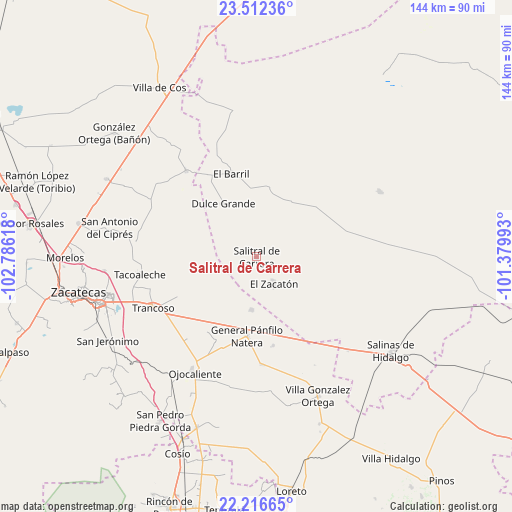
Salitral de Carrera GPS coordinates[2]
22° 51' 57.78" North, 102° 4' 58.98" West
| Map corner | latitude | longitude |
|---|---|---|
| Upper-left | 23.51236°, | -102.78618° |
| Center: | 22.86605°, | -102.08305° |
| Lower-right: | 22.21665°, | -101.37993° |
| Map W x H: | 144.1×144.1 km | = 89.5×89.5mi |
| max Lat: | 32.7° ⇑12.3% North |
| Salitral de Carrera: | 22.86605° |
| min Lat: | ⇓87.7% South 14.53588° |
| min Long | Salitral de Car | max Long |
| -117.105° | -102.08305° | -86.73105° |
| W 18.6%⇐ | ⇒81.4% E |
Elevation
Elevation of Salitral de Carrera is 2039 m = 6690 ft, and this is 785.3 m = 2576 ft above average elevation for this country.
| Max E: |
3497 m = 11473 ft | 24.5% |
| Salitral de Carrera | 2039 m 6690 ft | |
| Avg. | 1253.7 m = 4113 ft | |
Min E: |
-1 m = -3 ft | 75.5% |
See also: Mexico elevation on elevation.city.
Geographical zone
Salitral de Carrera is located in North Torrid zone (between Equator and Tropic of Cancer). Distance of this Northern Tropic circle is 63.5 km =39.5 mi to North.| Distance of | km | miles | from Salitral de Carrera |
|---|---|---|---|
| North Pole | 7464.6 | 4638.3 | to North |
| Arctic Circle | 4858.7 | 3019.1 | to North |
| Tropic Cancer | 63.5 | 39.5 | to North |
| Equator | 2542.5 | 1579.8 | to South |


Nearby cities:
15 places around Salitral de Carrera: (largest is in red/bold)
• Dulce Grande
17.7 km =11 mi,  328°
328°
• El Nuevo Mundo
19.2 km =11.9 mi,  220°
220°
• El Porvenir
15.5 km =9.6 mi,  250°
250°
• El Saucito (El Horno)
15.1 km =9.4 mi,  184°
184°
• Guanajuatillo
17.7 km =11 mi,  200°
200°
• Hernández
19.2 km =11.9 mi,  14°
14°
• La Dulcita
11.1 km =6.9 mi,  83°
83°
• La Tesorera
19.1 km =11.9 mi,  190°
190°
• Los Zacatones
11 km =6.8 mi, 14°
• Noria del Cerro de Santiago (El Cerro)
11.9 km =7.4 mi, 194°
• San Francisco
21.6 km =13.4 mi,  46°
46°
• San José el Saladillo (El Saladillo)
20.7 km =12.9 mi,  167°
167°
• Santa Lucía
19.1 km =11.9 mi,  118°
118°
• Sauz de Calera
10.7 km =6.6 mi,  270°
270°
• Villa de Ramos
18.1 km =11.2 mi,  102°
102°
Sources, notices
• [Note1] Compared only with cities in Mexico existing in our database
• [Src1] Map data: © OpenStreetMap contributors (CC-BY-SA)
• [Src2] Other city data from geonames.org with taken over terms of usage.
• [Src3] Geographical zone / Annual Mean Temperature by Robert A. Rohde @ Wikipedia
