El Nuevo Mundo geodata
El Nuevo Mundo (Zacatecas) is a populated place; located in Mexico in America/Mexico_City (GMT-6) time zone. With population of 638 people, there are 13580 cities with bigger population in this country. Compared to other cities in Mexico, 87.4% of cities are located further ↓South; 82% of cities are located further →East and 79.5% of cities have lower elevation than El Nuevo Mundo. Note1


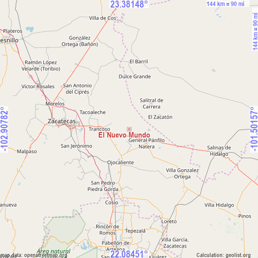
El Nuevo Mundo GPS coordinates[2]
22° 44' 4.308" North, 102° 12' 16.884" West
| Map corner | latitude | longitude |
|---|---|---|
| Upper-left | 23.38148°, | -102.90782° |
| Center: | 22.73453°, | -102.20469° |
| Lower-right: | 22.08451°, | -101.50157° |
| Map W x H: | 144.2×144.2 km | = 89.6×89.6mi |
| max Lat: | 32.7° ⇑12.6% North |
| El Nuevo Mundo: | 22.73453° |
| min Lat: | ⇓87.4% South 14.53588° |
| min Long | El Nuevo Mundo | max Long |
| -117.105° | -102.20469° | -86.73105° |
| W 18%⇐ | ⇒82% E |
Elevation
Elevation of El Nuevo Mundo is 2128 m = 6982 ft, and this is 874.3 m = 2868 ft above average elevation for this country.
| Max E: |
3497 m = 11473 ft | 20.5% |
| El Nuevo Mundo | 2128 m 6982 ft | |
| Avg. | 1253.7 m = 4113 ft | |
Min E: |
-1 m = -3 ft | 79.5% |
See also: Mexico elevation on elevation.city.
Geographical zone
El Nuevo Mundo is located in North Torrid zone (between Equator and Tropic of Cancer). Distance of this Northern Tropic circle is 78.1 km =48.5 mi to North.| Distance of | km | miles | from El Nuevo Mundo |
|---|---|---|---|
| North Pole | 7479.2 | 4647.4 | to North |
| Arctic Circle | 4873.3 | 3028.1 | to North |
| Tropic Cancer | 78.1 | 48.5 | to North |
| Equator | 2527.8 | 1570.7 | to South |


Nearby cities:
15 places around El Nuevo Mundo: (largest is in red/bold)
• Cerrito de la Cruz
11 km =6.8 mi,  219°
219°
• El Porvenir
9.6 km =6 mi,  347°
347°
• El Saucito (El Horno)
11.2 km =7 mi,  91°
91°
• General Pánfilo Natera
12.4 km =7.7 mi,  128°
128°
• Guanajuatillo
6.6 km =4.1 mi,  107°
107°
• La Capilla
6.3 km =3.9 mi,  212°
212°
• La Tesorera
9.9 km =6.2 mi, 114°
• Noria del Cerro de Santiago (El Cerro)
10 km =6.2 mi,  72°
72°
• Pozo de Jarillas
9.1 km =5.7 mi,  175°
175°
• Rancho Nuevo
16.6 km =10.3 mi,  147°
147°
• San Cristóbal
16.3 km =10.1 mi,  190°
190°
• San José del Carmen
8 km =5 mi,  296°
296°
• San Ramón
12.7 km =7.9 mi, 145°
• Sauz de Calera
14.9 km =9.3 mi,  6°
6°
• Trancoso
16.6 km =10.3 mi,  270°
270°
Sources, notices
• [Note1] Compared only with cities in Mexico existing in our database
• [Src1] Map data: © OpenStreetMap contributors (CC-BY-SA)
• [Src2] Other city data from geonames.org with taken over terms of usage.
• [Src3] Geographical zone / Annual Mean Temperature by Robert A. Rohde @ Wikipedia
