El Porvenir geodata
El Porvenir (Zacatecas) is a populated place; located in Mexico in America/Mexico_City (GMT-6) time zone. With population of 799 people, there are 10920 cities with bigger population in this country. Compared to other cities in Mexico, 87.6% of cities are located further ↓South; 82.2% of cities are located further →East and 77.6% of cities have lower elevation than El Porvenir. Note1


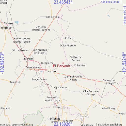
El Porvenir GPS coordinates[2]
22° 49' 8.004" North, 102° 13' 32.16" West
| Map corner | latitude | longitude |
|---|---|---|
| Upper-left | 23.46543°, | -102.92873° |
| Center: | 22.81889°, | -102.2256° |
| Lower-right: | 22.16926°, | -101.52248° |
| Map W x H: | 144.1×144.1 km | = 89.5×89.5mi |
| max Lat: | 32.7° ⇑12.4% North |
| El Porvenir: | 22.81889° |
| min Lat: | ⇓87.6% South 14.53588° |
| min Long | El Porvenir | max Long |
| -117.105° | -102.2256° | -86.73105° |
| W 17.8%⇐ | ⇒82.2% E |
Elevation
Elevation of El Porvenir is 2080 m = 6824 ft, and this is 826.3 m = 2711 ft above average elevation for this country.
| Max E: |
3497 m = 11473 ft | 22.4% |
| El Porvenir | 2080 m 6824 ft | |
| Avg. | 1253.7 m = 4113 ft | |
Min E: |
-1 m = -3 ft | 77.6% |
See also: Mexico elevation on elevation.city.
Geographical zone
El Porvenir is located in North Torrid zone (between Equator and Tropic of Cancer). Distance of this Northern Tropic circle is 68.7 km =42.7 mi to North.| Distance of | km | miles | from El Porvenir |
|---|---|---|---|
| North Pole | 7469.8 | 4641.5 | to North |
| Arctic Circle | 4864 | 3022.3 | to North |
| Tropic Cancer | 68.7 | 42.7 | to North |
| Equator | 2537.2 | 1576.5 | to South |


Nearby cities:
15 places around El Porvenir: (largest is in red/bold)
• Casa Blanca
11.1 km =6.9 mi,  311°
311°
• Cerrito de la Cruz
18.5 km =11.5 mi,  195°
195°
• El Nuevo Mundo
9.6 km =6 mi,  167°
167°
• El Saucito (El Horno)
16.5 km =10.3 mi,  126°
126°
• Guanajuatillo
14.2 km =8.8 mi,  143°
143°
• La Blanquita
15.9 km =9.9 mi,  257°
257°
• La Capilla
14.8 km =9.2 mi,  184°
184°
• La Luz
11 km =6.8 mi, 308°
• La Tesorera
17.6 km =10.9 mi, 140°
• Noria del Cerro de Santiago (El Cerro)
13.2 km =8.2 mi,  118°
118°
• Salitral de Carrera
15.5 km =9.6 mi,  70°
70°
• San José del Carmen
7.7 km =4.8 mi,  220°
220°
• Sauz de Calera
6.6 km =4.1 mi,  35°
35°
• Tacoaleche
18.4 km =11.4 mi,  270°
270°
• Trancoso
17.2 km =10.7 mi,  237°
237°
Sources, notices
• [Note1] Compared only with cities in Mexico existing in our database
• [Src1] Map data: © OpenStreetMap contributors (CC-BY-SA)
• [Src2] Other city data from geonames.org with taken over terms of usage.
• [Src3] Geographical zone / Annual Mean Temperature by Robert A. Rohde @ Wikipedia
