Sabinas geodata
Sabinas (Coahuila) is a seat of a second-order administrative division; located in Mexico in America/Monterrey (GMT-6) time zone. With population of 54,905 people, there are 206 cities with bigger population in this country. Compared to other cities in Mexico, 97.1% of cities are located further ↓South; 74.4% of cities are located further →East and 71.6% of cities have higher elevation than Sabinas. Note1


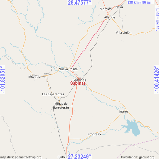
Sabinas GPS coordinates[2]
27° 51' 21.276" North, 101° 7' 2.568" West
| Map corner | latitude | longitude |
|---|---|---|
| Upper-left | 28.47577°, | -101.82051° |
| Center: | 27.85591°, | -101.11738° |
| Lower-right: | 27.23249°, | -100.41426° |
| Map W x H: | 138.2×138.2 km | = 85.9×85.9mi |
| max Lat: | 32.7° ⇑2.9% North |
| Sabinas: | 27.85591° |
| min Lat: | ⇓97.1% South 14.53588° |
| min Long | Sabinas | max Long |
| -117.105° | -101.11738° | -86.73105° |
| W 25.6%⇐ | ⇒74.4% E |
Elevation
Elevation of Sabinas is 342 m = 1122 ft, and this is 911.7 m = 2991 ft below average elevation for this country.
| Max E: |
3497 m = 11473 ft | 71.6% |
| Avg. | 1253.7 m = 4113 ft | |
| Sabinas | 342 m = 1122 ft | |
Min E: |
-1 m = -3 ft | 28.4% |
See also: Sabinas elevation on elevation.city.
Geographical zone
Sabinas is located in North temperate zone (between Tropic of Cancer and the Arctic Circle). Distance of this Northern Tropic circle is 491.4 km =305.3 mi to South.| Distance of | km | miles | from Sabinas |
|---|---|---|---|
| North Pole | 6909.8 | 4293.5 | to North |
| Arctic Circle | 4303.9 | 2674.3 | to North |
| Tropic Cancer | 491.4 | 305.3 | to South |
| Equator | 3097.3 | 1924.6 | to South |


Nearby cities:
15 places around Sabinas: (largest is in red/bold)
• Ciudad Melchor Múzquiz
39.3 km =24.4 mi,  273°
273°
• Cloete
9.2 km =5.7 mi,  321°
321°
• Juárez
47.3 km =29.4 mi,  125°
125°
• Minas de Barroterán
27.9 km =17.3 mi,  215°
215°
• Nueva Rosita
13.6 km =8.5 mi,  313°
313°
• Palau
30.3 km =18.8 mi,  277°
277°
• Progreso
49.2 km =30.6 mi,  165°
165°
• Rancherías
27.3 km =17 mi,  260°
260°
• Río Bravo
54.5 km =33.9 mi,  21°
21°
• San José de Aura
39 km =24.2 mi, 220°
• San Juan de Sabinas
20.2 km =12.6 mi,  293°
293°
• Santa María
33.4 km =20.8 mi,  295°
295°
• Valle Dorado
27.8 km =17.3 mi,  213°
213°
• Villa Las Esperanzas
26.4 km =16.4 mi,  241°
241°
• Villa Unión
56 km =34.8 mi,  43°
43°
Sources, notices
• [Note1] Compared only with cities in Mexico existing in our database
• [Src1] Map data: © OpenStreetMap contributors (CC-BY-SA)
• [Src2] Other city data from geonames.org with taken over terms of usage.
• [Src3] Geographical zone / Annual Mean Temperature by Robert A. Rohde @ Wikipedia
