Progreso geodata
Progreso (Coahuila) is a seat of a second-order administrative division; located in Mexico in America/Monterrey (GMT-6) time zone. With population of 796 people, there are 10956 cities with bigger population in this country. Compared to other cities in Mexico, 96.8% of cities are located further ↓South; 73.4% of cities are located further →East and 72.5% of cities have higher elevation than Progreso. Note1


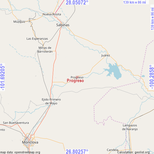
Progreso GPS coordinates[2]
27° 25' 42.276" North, 100° 59' 20.112" West
| Map corner | latitude | longitude |
|---|---|---|
| Upper-left | 28.05072°, | -101.69205° |
| Center: | 27.42841°, | -100.98892° |
| Lower-right: | 26.80257°, | -100.2858° |
| Map W x H: | 138.8×138.8 km | = 86.2×86.2mi |
| max Lat: | 32.7° ⇑3.2% North |
| Progreso: | 27.42841° |
| min Lat: | ⇓96.8% South 14.53588° |
| min Long | Progreso | max Long |
| -117.105° | -100.98892° | -86.73105° |
| W 26.6%⇐ | ⇒73.4% E |
Elevation
Elevation of Progreso is 309 m = 1014 ft, and this is 944.7 m = 3099 ft below average elevation for this country.
| Max E: |
3497 m = 11473 ft | 72.5% |
| Avg. | 1253.7 m = 4113 ft | |
| Progreso | 309 m = 1014 ft | |
Min E: |
-1 m = -3 ft | 27.5% |
See also: Mexico elevation on elevation.city.
Geographical zone
Progreso is located in North temperate zone (between Tropic of Cancer and the Arctic Circle). Distance of this Northern Tropic circle is 443.8 km =275.8 mi to South.| Distance of | km | miles | from Progreso |
|---|---|---|---|
| North Pole | 6957.3 | 4323.1 | to North |
| Arctic Circle | 4351.4 | 2703.8 | to North |
| Tropic Cancer | 443.8 | 275.8 | to South |
| Equator | 3049.8 | 1895.1 | to South |


Nearby cities:
15 places around Progreso: (largest is in red/bold)
• Abasolo
51.3 km =31.9 mi,  237°
237°
• Cloete
57.8 km =35.9 mi,  341°
341°
• Escobedo
47.2 km =29.3 mi, 242°
• Juárez
32.6 km =20.3 mi,  52°
52°
• Lampazos de Naranjo
65.5 km =40.7 mi,  133°
133°
• Minas de Barroterán
38.1 km =23.7 mi,  310°
310°
• Nueva Rosita
61.2 km =38 mi, 338°
• Palau
67 km =41.6 mi,  320°
320°
• Primero de Mayo
31.5 km =19.6 mi,  227°
227°
• Rancherías
58.7 km =36.5 mi, 317°
• Sabinas
49.2 km =30.6 mi,  345°
345°
• San José de Aura
41.8 km =26 mi,  295°
295°
• San Juan de Sabinas
63.8 km =39.6 mi,  330°
330°
• Valle Dorado
37 km =23 mi, 311°
• Villa Las Esperanzas
50.1 km =31.1 mi, 314°
Sources, notices
• [Note1] Compared only with cities in Mexico existing in our database
• [Src1] Map data: © OpenStreetMap contributors (CC-BY-SA)
• [Src2] Other city data from geonames.org with taken over terms of usage.
• [Src3] Geographical zone / Annual Mean Temperature by Robert A. Rohde @ Wikipedia
