Chilapa geodata
Chilapa (Nayarit) is a populated place; located in Mexico in America/Mazatlan (GMT-7) time zone. With population of 1,953 people, there are 4464 cities with bigger population in this country. Compared to other cities in Mexico, 84.4% of cities are located further ↓South; 92.4% of cities are located further →East and 91.2% of cities have higher elevation than Chilapa. Note1


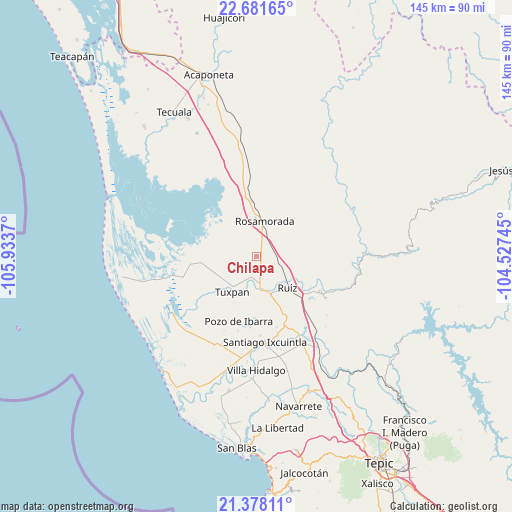
Chilapa GPS coordinates[2]
22° 1' 52.968" North, 105° 13' 50.052" West
| Map corner | latitude | longitude |
|---|---|---|
| Upper-left | 22.68165°, | -105.9337° |
| Center: | 22.03138°, | -105.23057° |
| Lower-right: | 21.37811°, | -104.52745° |
| Map W x H: | 144.9×144.9 km | = 90×90mi |
| max Lat: | 32.7° ⇑15.6% North |
| Chilapa: | 22.03138° |
| min Lat: | ⇓84.4% South 14.53588° |
| min Long | Chilapa | max Long |
| -117.105° | -105.23057° | -86.73105° |
| W 7.6%⇐ | ⇒92.4% E |
Elevation
Elevation of Chilapa is 21 m = 69 ft, and this is 1232.7 m = 4044 ft below average elevation for this country.
| Max E: |
3497 m = 11473 ft | 91.2% |
| Avg. | 1253.7 m = 4113 ft | |
| Chilapa | 21 m = 69 ft | |
Min E: |
-1 m = -3 ft | 8.8% |
See also: Mexico elevation on elevation.city.
Geographical zone
Chilapa is located in North Torrid zone (between Equator and Tropic of Cancer). Distance of this Northern Tropic circle is 156.3 km =97.1 mi to North.| Distance of | km | miles | from Chilapa |
|---|---|---|---|
| North Pole | 7557.4 | 4695.9 | to North |
| Arctic Circle | 4951.5 | 3076.7 | to North |
| Tropic Cancer | 156.3 | 97.1 | to North |
| Equator | 2449.7 | 1522.2 | to South |


Nearby cities:
15 places around Chilapa: (largest is in red/bold)
• Cofradía de Cuyutlán
12.1 km =7.5 mi,  77°
77°
• Cuamiles
12.2 km =7.6 mi,  191°
191°
• El Tamarindo
8.1 km =5 mi,  181°
181°
• El Vado de San Pedro
10.7 km =6.6 mi,  150°
150°
• La Boquita
12.1 km =7.5 mi,  253°
253°
• Las Pilas
7 km =4.3 mi,  87°
87°
• Llano del Tigre
13.2 km =8.2 mi,  323°
323°
• Los Medina
13.4 km =8.3 mi,  256°
256°
• Paramita
12.6 km =7.8 mi,  18°
18°
• Paso Real del Bejuco
4.7 km =2.9 mi,  105°
105°
• Pericos
12.9 km =8 mi,  278°
278°
• Rosamorada
10.4 km =6.5 mi,  13°
13°
• Ruíz
12.6 km =7.8 mi,  134°
134°
• San Vicente
11.3 km =7 mi,  217°
217°
• Tuxpan
12.2 km =7.6 mi, 215°
Sources, notices
• [Note1] Compared only with cities in Mexico existing in our database
• [Src1] Map data: © OpenStreetMap contributors (CC-BY-SA)
• [Src2] Other city data from geonames.org with taken over terms of usage.
• [Src3] Geographical zone / Annual Mean Temperature by Robert A. Rohde @ Wikipedia
