El Tamarindo geodata
El Tamarindo (Nayarit) is a populated place; located in Mexico in America/Mazatlan (GMT-7) time zone. With population of 1,548 people, there are 5570 cities with bigger population in this country. Compared to other cities in Mexico, 83.9% of cities are located further ↓South; 92.5% of cities are located further →East and 92.5% of cities have higher elevation than El Tamarindo. Note1


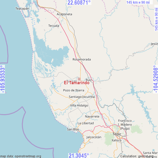
El Tamarindo GPS coordinates[2]
21° 57' 29.16" North, 105° 13' 55.92" West
| Map corner | latitude | longitude |
|---|---|---|
| Upper-left | 22.60871°, | -105.93533° |
| Center: | 21.9581°, | -105.2322° |
| Lower-right: | 21.3045°, | -104.52908° |
| Map W x H: | 145×145 km | = 90.1×90.1mi |
| max Lat: | 32.7° ⇑16.1% North |
| El Tamarindo: | 21.9581° |
| min Lat: | ⇓83.9% South 14.53588° |
| min Long | El Tamarindo | max Long |
| -117.105° | -105.2322° | -86.73105° |
| W 7.5%⇐ | ⇒92.5% E |
Elevation
Elevation of El Tamarindo is 18 m = 59 ft, and this is 1235.7 m = 4054 ft below average elevation for this country.
| Max E: |
3497 m = 11473 ft | 92.5% |
| Avg. | 1253.7 m = 4113 ft | |
| El Tamarindo | 18 m = 59 ft | |
Min E: |
-1 m = -3 ft | 7.5% |
See also: Mexico elevation on elevation.city.
Geographical zone
El Tamarindo is located in North Torrid zone (between Equator and Tropic of Cancer). Distance of this Northern Tropic circle is 164.4 km =102.2 mi to North.| Distance of | km | miles | from El Tamarindo |
|---|---|---|---|
| North Pole | 7565.6 | 4701 | to North |
| Arctic Circle | 4959.7 | 3081.8 | to North |
| Tropic Cancer | 164.4 | 102.2 | to North |
| Equator | 2441.5 | 1517.1 | to South |


Nearby cities:
15 places around El Tamarindo: (largest is in red/bold)
• Chilapa
8.1 km =5 mi,  1°
1°
• Cuamiles
4.5 km =2.8 mi,  210°
210°
• El Puente
12.1 km =7.5 mi,  187°
187°
• El Vado de San Pedro
5.5 km =3.4 mi,  102°
102°
• Heroico Batallón de San Blas
9.3 km =5.8 mi,  129°
129°
• La Boquita
12.3 km =7.6 mi,  292°
292°
• Las Pilas
11.1 km =6.9 mi,  40°
40°
• Los Medina
13.8 km =8.6 mi, 291°
• Paredones (La Punta de la Laguna)
9.9 km =6.2 mi,  165°
165°
• Paso Real del Bejuco
8.3 km =5.2 mi,  34°
34°
• Pozo de Ibarra
11.3 km =7 mi, 205°
• Ruíz
9.1 km =5.7 mi,  94°
94°
• San Vicente
6.7 km =4.2 mi,  262°
262°
• Tuxpan
7.1 km =4.4 mi, 255°
• Valle Morelos
14 km =8.7 mi,  201°
201°
Sources, notices
• [Note1] Compared only with cities in Mexico existing in our database
• [Src1] Map data: © OpenStreetMap contributors (CC-BY-SA)
• [Src2] Other city data from geonames.org with taken over terms of usage.
• [Src3] Geographical zone / Annual Mean Temperature by Robert A. Rohde @ Wikipedia
