Pitiquito geodata
Pitiquito (Sonora) is a seat of a second-order administrative division; located in Mexico in America/Hermosillo (GMT-7) time zone. With population of 5,410 people, there are 1713 cities with bigger population in this country. Compared to other cities in Mexico, 98.7% of cities are located further ↓South; 98.8% of cities are located further →East and 72.3% of cities have higher elevation than Pitiquito. Note1


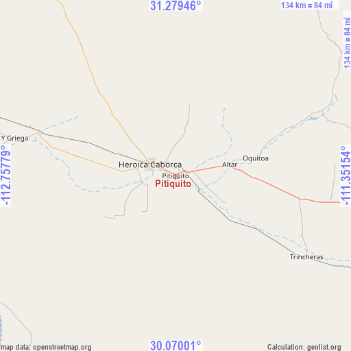
Pitiquito GPS coordinates[2]
30° 40' 35.868" North, 112° 3' 16.776" West
| Map corner | latitude | longitude |
|---|---|---|
| Upper-left | 31.27946°, | -112.75779° |
| Center: | 30.67663°, | -112.05466° |
| Lower-right: | 30.07001°, | -111.35154° |
| Map W x H: | 134.5×134.5 km | = 83.6×83.6mi |
| max Lat: | 32.7° ⇑1.3% North |
| Pitiquito: | 30.67663° |
| min Lat: | ⇓98.7% South 14.53588° |
| min Long | Pitiquito | max Long |
| -117.105° | -112.05466° | -86.73105° |
| W 1.2%⇐ | ⇒98.8% E |
Elevation
Elevation of Pitiquito is 318 m = 1043 ft, and this is 935.7 m = 3070 ft below average elevation for this country.
| Max E: |
3497 m = 11473 ft | 72.3% |
| Avg. | 1253.7 m = 4113 ft | |
| Pitiquito | 318 m = 1043 ft | |
Min E: |
-1 m = -3 ft | 27.7% |
See also: Mexico elevation on elevation.city.
Geographical zone
Pitiquito is located in North temperate zone (between Tropic of Cancer and the Arctic Circle). Distance of this Northern Tropic circle is 805 km =500.2 mi to South.| Distance of | km | miles | from Pitiquito |
|---|---|---|---|
| North Pole | 6596.1 | 4098.6 | to North |
| Arctic Circle | 3990.3 | 2479.5 | to North |
| Tropic Cancer | 805 | 500.2 | to South |
| Equator | 3410.9 | 2119.4 | to South |


Nearby cities:
15 places around Pitiquito: (largest is in red/bold)
• Altar
21.2 km =13.2 mi,  78°
78°
• Atil
48.7 km =30.3 mi,  67°
67°
• El Coyote
56.2 km =34.9 mi,  287°
287°
• El Diamante (La Retranca)
59 km =36.7 mi, 288°
• Heroica Caborca
10.9 km =6.8 mi,  295°
295°
• La Alameda (Cortázar)
70.3 km =43.7 mi,  274°
274°
• La Almita
36.4 km =22.6 mi,  275°
275°
• Oquitoa
31.4 km =19.5 mi, 76°
• Plutarco Elías Calles (La Y Griega)
64.9 km =40.3 mi, 282°
• Poblado San Felipe
75.3 km =46.8 mi, 283°
• Siempre Viva
38.9 km =24.2 mi, 281°
• Trincheras
59 km =36.7 mi,  121°
121°
• Tubutama
60.9 km =37.8 mi, 67°
• Viñedo Viva (Pozo 5)
25.6 km =15.9 mi, 275°
• Último Esfuerzo
76.5 km =47.5 mi, 279°
Sources, notices
• [Note1] Compared only with cities in Mexico existing in our database
• [Src1] Map data: © OpenStreetMap contributors (CC-BY-SA)
• [Src2] Other city data from geonames.org with taken over terms of usage.
• [Src3] Geographical zone / Annual Mean Temperature by Robert A. Rohde @ Wikipedia
