Tubutama geodata
Tubutama (Sonora) is a seat of a second-order administrative division; located in Mexico in America/Hermosillo (GMT-7) time zone. With population of 348 people, there are 16859 cities with bigger population in this country. Compared to other cities in Mexico, 98.9% of cities are located further ↓South; 98.7% of cities are located further →East and 65.7% of cities have higher elevation than Tubutama. Note1


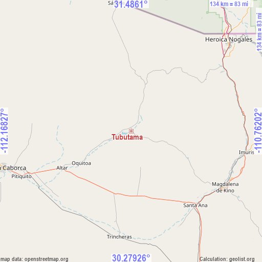
Tubutama GPS coordinates[2]
30° 53' 4.488" North, 111° 27' 54.504" West
| Map corner | latitude | longitude |
|---|---|---|
| Upper-left | 31.4861°, | -112.16827° |
| Center: | 30.88458°, | -111.46514° |
| Lower-right: | 30.27926°, | -110.76202° |
| Map W x H: | 134.2×134.2 km | = 83.4×83.4mi |
| max Lat: | 32.7° ⇑1.1% North |
| Tubutama: | 30.88458° |
| min Lat: | ⇓98.9% South 14.53588° |
| min Long | Tubutama | max Long |
| -117.105° | -111.46514° | -86.73105° |
| W 1.3%⇐ | ⇒98.7% E |
Elevation
Elevation of Tubutama is 650 m = 2133 ft, and this is 603.7 m = 1981 ft below average elevation for this country.
| Max E: |
3497 m = 11473 ft | 65.7% |
| Avg. | 1253.7 m = 4113 ft | |
| Tubutama | 650 m = 2133 ft | |
Min E: |
-1 m = -3 ft | 34.3% |
See also: Mexico elevation on elevation.city.
Geographical zone
Tubutama is located in North temperate zone (between Tropic of Cancer and the Arctic Circle). Distance of this Northern Tropic circle is 828.1 km =514.6 mi to South.| Distance of | km | miles | from Tubutama |
|---|---|---|---|
| North Pole | 6573 | 4084.3 | to North |
| Arctic Circle | 3967.1 | 2465 | to North |
| Tropic Cancer | 828.1 | 514.6 | to South |
| Equator | 3434 | 2133.8 | to South |


Nearby cities:
15 places around Tubutama: (largest is in red/bold)
• Altar
40.2 km =25 mi,  242°
242°
• Atil
12.2 km =7.6 mi,  248°
248°
• Centro de Readaptación Social Nuevo
57.9 km =36 mi,  54°
54°
• Cíbuta
57.5 km =35.7 mi,  70°
70°
• El Claro
54.2 km =33.7 mi,  152°
152°
• El Tasicuri
56.5 km =35.1 mi,  115°
115°
• La Estación
57.9 km =36 mi,  101°
101°
• La Mesa
55.9 km =34.7 mi,  56°
56°
• Magdalena de Kino
55.9 km =34.7 mi, 120°
• Oquitoa
30.2 km =18.8 mi, 238°
• San Ignacio
55.9 km =34.7 mi,  111°
111°
• Santa Ana
50.6 km =31.4 mi,  139°
139°
• Santa Ana Viejo
48.9 km =30.4 mi, 140°
• Sáric
25.7 km =16 mi,  18°
18°
• Trincheras
54.5 km =33.9 mi,  186°
186°
Sources, notices
• [Note1] Compared only with cities in Mexico existing in our database
• [Src1] Map data: © OpenStreetMap contributors (CC-BY-SA)
• [Src2] Other city data from geonames.org with taken over terms of usage.
• [Src3] Geographical zone / Annual Mean Temperature by Robert A. Rohde @ Wikipedia
