Oquitoa geodata
Oquitoa (Sonora) is a seat of a second-order administrative division; located in Mexico in America/Hermosillo (GMT-7) time zone. With population of 411 people, there are 16841 cities with bigger population in this country. Compared to other cities in Mexico, 98.8% of cities are located further ↓South; 98.8% of cities are located further →East and 68.8% of cities have higher elevation than Oquitoa. Note1


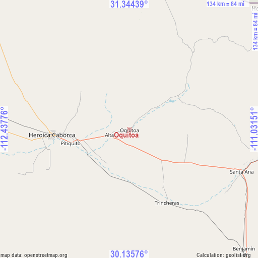
Oquitoa GPS coordinates[2]
30° 44' 31.092" North, 111° 44' 4.668" West
| Map corner | latitude | longitude |
|---|---|---|
| Upper-left | 31.34439°, | -112.43776° |
| Center: | 30.74197°, | -111.73463° |
| Lower-right: | 30.13576°, | -111.03151° |
| Map W x H: | 134.4×134.4 km | = 83.5×83.5mi |
| max Lat: | 32.7° ⇑1.2% North |
| Oquitoa: | 30.74197° |
| min Lat: | ⇓98.8% South 14.53588° |
| min Long | Oquitoa | max Long |
| -117.105° | -111.73463° | -86.73105° |
| W 1.2%⇐ | ⇒98.8% E |
Elevation
Elevation of Oquitoa is 478 m = 1568 ft, and this is 775.7 m = 2545 ft below average elevation for this country.
| Max E: |
3497 m = 11473 ft | 68.8% |
| Avg. | 1253.7 m = 4113 ft | |
| Oquitoa | 478 m = 1568 ft | |
Min E: |
-1 m = -3 ft | 31.2% |
See also: Mexico elevation on elevation.city.
Geographical zone
Oquitoa is located in North temperate zone (between Tropic of Cancer and the Arctic Circle). Distance of this Northern Tropic circle is 812.3 km =504.7 mi to South.| Distance of | km | miles | from Oquitoa |
|---|---|---|---|
| North Pole | 6588.9 | 4094.2 | to North |
| Arctic Circle | 3983 | 2474.9 | to North |
| Tropic Cancer | 812.3 | 504.7 | to South |
| Equator | 3418.2 | 2124 | to South |


Nearby cities:
15 places around Oquitoa: (largest is in red/bold)
• Altar
10.2 km =6.3 mi,  253°
253°
• Atil
18.3 km =11.4 mi,  51°
51°
• El Claro
60.2 km =37.4 mi,  122°
122°
• Estación Llano
73.7 km =45.8 mi,  125°
125°
• Heroica Caborca
40.6 km =25.2 mi,  266°
266°
• La Almita
66.9 km =41.6 mi, 266°
• Magdalena de Kino
75 km =46.6 mi,  99°
99°
• Pitiquito
31.4 km =19.5 mi,  256°
256°
• Santa Ana
63 km =39.1 mi,  110°
110°
• Santa Ana Viejo
61.1 km =38 mi, 110°
• Siempre Viva
68.7 km =42.7 mi, 270°
• Sáric
52.6 km =32.7 mi,  40°
40°
• Trincheras
43 km =26.7 mi,  152°
152°
• Tubutama
30.2 km =18.8 mi,  58°
58°
• Viñedo Viva (Pozo 5)
56.3 km =35 mi, 264°
Sources, notices
• [Note1] Compared only with cities in Mexico existing in our database
• [Src1] Map data: © OpenStreetMap contributors (CC-BY-SA)
• [Src2] Other city data from geonames.org with taken over terms of usage.
• [Src3] Geographical zone / Annual Mean Temperature by Robert A. Rohde @ Wikipedia
