Batury geodata
Batury (Sinaloa) is a populated place; located in Mexico in America/Mazatlan (GMT-7) time zone. With population of 999 people, there are 8726 cities with bigger population in this country. Compared to other cities in Mexico, 92.1% of cities are located further ↓South; 95.8% of cities are located further →East and 95.7% of cities have higher elevation than Batury. Note1


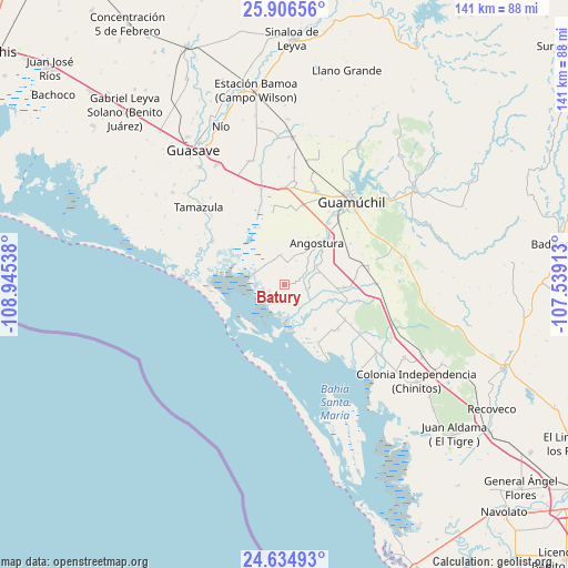
Batury GPS coordinates[2]
25° 16' 20.676" North, 108° 14' 32.1" West
| Map corner | latitude | longitude |
|---|---|---|
| Upper-left | 25.90656°, | -108.94538° |
| Center: | 25.27241°, | -108.24225° |
| Lower-right: | 24.63493°, | -107.53913° |
| Map W x H: | 141.4×141.4 km | = 87.9×87.9mi |
| max Lat: | 32.7° ⇑7.9% North |
| Batury: | 25.27241° |
| min Lat: | ⇓92.1% South 14.53588° |
| min Long | Batury | max Long |
| -117.105° | -108.24225° | -86.73105° |
| W 4.2%⇐ | ⇒95.8% E |
Elevation
Elevation of Batury is 12 m = 39 ft, and this is 1241.7 m = 4074 ft below average elevation for this country.
| Max E: |
3497 m = 11473 ft | 95.7% |
| Avg. | 1253.7 m = 4113 ft | |
| Batury | 12 m = 39 ft | |
Min E: |
-1 m = -3 ft | 4.3% |
See also: Mexico elevation on elevation.city.
Geographical zone
Batury is located in North temperate zone (between Tropic of Cancer and the Arctic Circle). Distance of this Northern Tropic circle is 204.1 km =126.8 mi to South.| Distance of | km | miles | from Batury |
|---|---|---|---|
| North Pole | 7197 | 4472 | to North |
| Arctic Circle | 4591.1 | 2852.8 | to North |
| Tropic Cancer | 204.1 | 126.8 | to South |
| Equator | 2810 | 1746.1 | to South |


Nearby cities:
15 places around Batury: (largest is in red/bold)
• Alhuey
16.3 km =10.1 mi,  43°
43°
• Angostura
13.2 km =8.2 mi, 38°
• Capomos
19.1 km =11.9 mi, 36°
• Cruz Blanca
20 km =12.4 mi,  350°
350°
• El Ébano
8.2 km =5.1 mi,  45°
45°
• Estación Acatita
21.2 km =13.2 mi,  79°
79°
• Gabriel Leyva Velázquez (La Escalera)
20.1 km =12.5 mi,  13°
13°
• Gustavo Díaz Ordaz
14.8 km =9.2 mi,  92°
92°
• La Brecha
20.9 km =13 mi,  301°
301°
• La Esperanza
10.2 km =6.3 mi,  33°
33°
• La Palma
14.9 km =9.3 mi, 34°
• Las Colonias (Colonia Ángel Flores)
19 km =11.8 mi,  322°
322°
• Playa Colorada
8.5 km =5.3 mi,  283°
283°
• Rodolfo Sánchez Taboada (Las Lagunitas)
18.4 km =11.4 mi, 350°
• San José de la Brecha
21.2 km =13.2 mi,  291°
291°
Sources, notices
• [Note1] Compared only with cities in Mexico existing in our database
• [Src1] Map data: © OpenStreetMap contributors (CC-BY-SA)
• [Src2] Other city data from geonames.org with taken over terms of usage.
• [Src3] Geographical zone / Annual Mean Temperature by Robert A. Rohde @ Wikipedia
