La Esperanza geodata
La Esperanza (Sinaloa) is a populated place; located in Mexico in America/Mazatlan (GMT-7) time zone. With population of 1,565 people, there are 5519 cities with bigger population in this country. Compared to other cities in Mexico, 92.3% of cities are located further ↓South; 95.8% of cities are located further →East and 91.2% of cities have higher elevation than La Esperanza. Note1


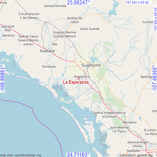
La Esperanza GPS coordinates[2]
25° 20' 55.392" North, 108° 11' 12.408" West
| Map corner | latitude | longitude |
|---|---|---|
| Upper-left | 25.98247°, | -108.88991° |
| Center: | 25.34872°, | -108.18678° |
| Lower-right: | 24.71163°, | -107.48366° |
| Map W x H: | 141.3×141.3 km | = 87.8×87.8mi |
| max Lat: | 32.7° ⇑7.7% North |
| La Esperanza: | 25.34872° |
| min Lat: | ⇓92.3% South 14.53588° |
| min Long | La Esperanza | max Long |
| -117.105° | -108.18678° | -86.73105° |
| W 4.2%⇐ | ⇒95.8% E |
Elevation
Elevation of La Esperanza is 21 m = 69 ft, and this is 1232.7 m = 4044 ft below average elevation for this country.
| Max E: |
3497 m = 11473 ft | 91.2% |
| Avg. | 1253.7 m = 4113 ft | |
| La Esperanza | 21 m = 69 ft | |
Min E: |
-1 m = -3 ft | 8.8% |
See also: Mexico elevation on elevation.city.
Geographical zone
La Esperanza is located in North temperate zone (between Tropic of Cancer and the Arctic Circle). Distance of this Northern Tropic circle is 212.6 km =132.1 mi to South.| Distance of | km | miles | from La Esperanza |
|---|---|---|---|
| North Pole | 7188.5 | 4466.7 | to North |
| Arctic Circle | 4582.7 | 2847.6 | to North |
| Tropic Cancer | 212.6 | 132.1 | to South |
| Equator | 2818.5 | 1751.3 | to South |


Nearby cities:
15 places around La Esperanza: (largest is in red/bold)
• Alhuey
6.5 km =4 mi,  60°
60°
• Angostura
3.2 km =2 mi,  53°
53°
• Batury
10.2 km =6.3 mi,  213°
213°
• Capomos
9 km =5.6 mi,  40°
40°
• Cruz Blanca
14.3 km =8.9 mi,  322°
322°
• El Salitre
11.2 km =7 mi,  29°
29°
• El Taballal
16.1 km =10 mi, 63°
• El Ébano
2.8 km =1.7 mi,  173°
173°
• Estación Acatita
16 km =9.9 mi,  107°
107°
• Gabriel Leyva Velázquez (La Escalera)
11.2 km =7 mi,  354°
354°
• Gustavo Díaz Ordaz
13 km =8.1 mi,  134°
134°
• La Palma
4.7 km =2.9 mi, 36°
• Playa Colorada
15.3 km =9.5 mi,  244°
244°
• Rodolfo Sánchez Taboada (Las Lagunitas)
12.9 km =8 mi, 318°
• San Isidro
11.4 km =7.1 mi, 38°
Sources, notices
• [Note1] Compared only with cities in Mexico existing in our database
• [Src1] Map data: © OpenStreetMap contributors (CC-BY-SA)
• [Src2] Other city data from geonames.org with taken over terms of usage.
• [Src3] Geographical zone / Annual Mean Temperature by Robert A. Rohde @ Wikipedia
