Angostura geodata
Angostura (Sinaloa) is a seat of a second-order administrative division; located in Mexico in America/Mazatlan (GMT-7) time zone. With population of 5,086 people, there are 1821 cities with bigger population in this country. Compared to other cities in Mexico, 92.3% of cities are located further ↓South; 95.8% of cities are located further →East and 88.6% of cities have higher elevation than Angostura. Note1


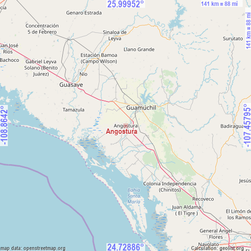
Angostura GPS coordinates[2]
25° 21' 57.096" North, 108° 9' 39.852" West
| Map corner | latitude | longitude |
|---|---|---|
| Upper-left | 25.99952°, | -108.8642° |
| Center: | 25.36586°, | -108.16107° |
| Lower-right: | 24.72886°, | -107.45795° |
| Map W x H: | 141.3×141.3 km | = 87.8×87.8mi |
| max Lat: | 32.7° ⇑7.7% North |
| Angostura: | 25.36586° |
| min Lat: | ⇓92.3% South 14.53588° |
| min Long | Angostura | max Long |
| -117.105° | -108.16107° | -86.73105° |
| W 4.2%⇐ | ⇒95.8% E |
Elevation
Elevation of Angostura is 28 m = 92 ft, and this is 1225.7 m = 4021 ft below average elevation for this country.
| Max E: |
3497 m = 11473 ft | 88.6% |
| Avg. | 1253.7 m = 4113 ft | |
| Angostura | 28 m = 92 ft | |
Min E: |
-1 m = -3 ft | 11.4% |
See also: Mexico elevation on elevation.city.
Geographical zone
Angostura is located in North temperate zone (between Tropic of Cancer and the Arctic Circle). Distance of this Northern Tropic circle is 214.5 km =133.3 mi to South.| Distance of | km | miles | from Angostura |
|---|---|---|---|
| North Pole | 7186.6 | 4465.5 | to North |
| Arctic Circle | 4580.8 | 2846.4 | to North |
| Tropic Cancer | 214.5 | 133.3 | to South |
| Equator | 2820.4 | 1752.5 | to South |


Nearby cities:
15 places around Angostura: (largest is in red/bold)
• Alhuey
3.4 km =2.1 mi,  66°
66°
• Batury
13.2 km =8.2 mi,  218°
218°
• Capomos
5.9 km =3.7 mi,  33°
33°
• El Salitre
8.4 km =5.2 mi,  20°
20°
• El Taballal
12.9 km =8 mi, 66°
• El Ébano
5.2 km =3.2 mi,  206°
206°
• Estación Acatita
14.3 km =8.9 mi,  117°
117°
• Gabriel Leyva Velázquez (La Escalera)
9.9 km =6.2 mi,  338°
338°
• Guamúchil
13.3 km =8.3 mi,  39°
39°
• Gustavo Díaz Ordaz
12.9 km =8 mi,  148°
148°
• La Esperanza
3.2 km =2 mi,  233°
233°
• La Palma
1.9 km =1.2 mi,  6°
6°
• Rodolfo Sánchez Taboada (Las Lagunitas)
13.6 km =8.5 mi,  304°
304°
• San Isidro
8.3 km =5.2 mi, 32°
• Tultita
13.9 km =8.6 mi,  51°
51°
Sources, notices
• [Note1] Compared only with cities in Mexico existing in our database
• [Src1] Map data: © OpenStreetMap contributors (CC-BY-SA)
• [Src2] Other city data from geonames.org with taken over terms of usage.
• [Src3] Geographical zone / Annual Mean Temperature by Robert A. Rohde @ Wikipedia
