Nieves geodata
Nieves (Zacatecas) is a seat of a second-order administrative division; located in Mexico in America/Mexico_City (GMT-6) time zone. With population of 5,653 people, there are 1647 cities with bigger population in this country. Compared to other cities in Mexico, 90% of cities are located further ↓South; 85.8% of cities are located further →East and 69.4% of cities have lower elevation than Nieves. Note1


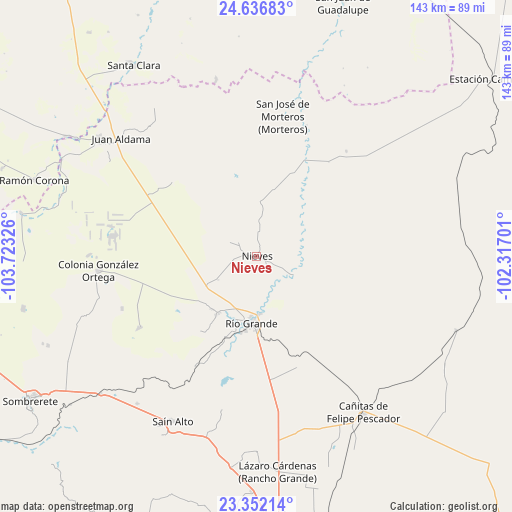
Nieves GPS coordinates[2]
23° 59' 45.924" North, 103° 1' 12.468" West
| Map corner | latitude | longitude |
|---|---|---|
| Upper-left | 24.63683°, | -103.72326° |
| Center: | 23.99609°, | -103.02013° |
| Lower-right: | 23.35214°, | -102.31701° |
| Map W x H: | 142.8×142.8 km | = 88.7×88.7mi |
| max Lat: | 32.7° ⇑10% North |
| Nieves: | 23.99609° |
| min Lat: | ⇓90% South 14.53588° |
| min Long | Nieves | max Long |
| -117.105° | -103.02013° | -86.73105° |
| W 14.2%⇐ | ⇒85.8% E |
Elevation
Elevation of Nieves is 1914 m = 6280 ft, and this is 660.3 m = 2166 ft above average elevation for this country.
| Max E: |
3497 m = 11473 ft | 30.6% |
| Nieves | 1914 m 6280 ft | |
| Avg. | 1253.7 m = 4113 ft | |
Min E: |
-1 m = -3 ft | 69.4% |
See also: Mexico elevation on elevation.city.
Geographical zone
Nieves is located in North temperate zone (between Tropic of Cancer and the Arctic Circle). Distance of this Northern Tropic circle is 62.2 km =38.6 mi to South.| Distance of | km | miles | from Nieves |
|---|---|---|---|
| North Pole | 7338.9 | 4560.2 | to North |
| Arctic Circle | 4733.1 | 2941 | to North |
| Tropic Cancer | 62.2 | 38.6 | to South |
| Equator | 2668.1 | 1657.9 | to South |


Nearby cities:
15 places around Nieves: (largest is in red/bold)
• Cieneguilla (Noria y Cieneguilla)
8.8 km =5.5 mi,  297°
297°
• El Fuerte
18.9 km =11.7 mi,  213°
213°
• Francisco I. Madero
9.9 km =6.2 mi,  137°
137°
• Independencia San Martín (San Martín)
9.7 km =6 mi,  317°
317°
• José María Morelos y Pavón
19.3 km =12 mi,  219°
219°
• La Estanzuela
12.5 km =7.8 mi,  238°
238°
• Las Esperanzas (El Ranchito)
19.8 km =12.3 mi, 214°
• Loreto
16.2 km =10.1 mi,  176°
176°
• Los Condes
18.5 km =11.5 mi,  198°
198°
• Los Ramírez
16.9 km =10.5 mi, 184°
• Luis Moya
18.8 km =11.7 mi,  40°
40°
• Oran
12 km =7.5 mi,  102°
102°
• Río Grande
18.9 km =11.7 mi, 183°
• Santa Rita
12 km =7.5 mi,  118°
118°
• Tierra Blanca
19.6 km =12.2 mi, 197°
Sources, notices
• [Note1] Compared only with cities in Mexico existing in our database
• [Src1] Map data: © OpenStreetMap contributors (CC-BY-SA)
• [Src2] Other city data from geonames.org with taken over terms of usage.
• [Src3] Geographical zone / Annual Mean Temperature by Robert A. Rohde @ Wikipedia
