Neutla geodata
Neutla (Guanajuato) is a populated place; located in Mexico in America/Mexico_City (GMT-6) time zone. With population of 3,797 people, there are 2407 cities with bigger population in this country. Compared to other cities in Mexico, 71.8% of cities are located further ↓South; 72.1% of cities are located further →East and 64.9% of cities have lower elevation than Neutla. Note1


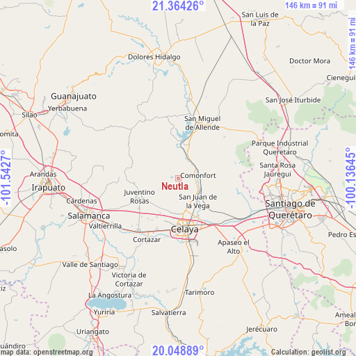
Neutla GPS coordinates[2]
20° 42' 28.8" North, 100° 50' 22.452" West
| Map corner | latitude | longitude |
|---|---|---|
| Upper-left | 21.36426°, | -101.5427° |
| Center: | 20.708°, | -100.83957° |
| Lower-right: | 20.04889°, | -100.13645° |
| Map W x H: | 146.3×146.3 km | = 90.9×90.9mi |
| max Lat: | 32.7° ⇑28.2% North |
| Neutla: | 20.708° |
| min Lat: | ⇓71.8% South 14.53588° |
| min Long | Neutla | max Long |
| -117.105° | -100.83957° | -86.73105° |
| W 27.9%⇐ | ⇒72.1% E |
Elevation
Elevation of Neutla is 1826 m = 5991 ft, and this is 572.3 m = 1878 ft above average elevation for this country.
| Max E: |
3497 m = 11473 ft | 35.1% |
| Neutla | 1826 m 5991 ft | |
| Avg. | 1253.7 m = 4113 ft | |
Min E: |
-1 m = -3 ft | 64.9% |
See also: Mexico elevation on elevation.city.
Geographical zone
Neutla is located in North Torrid zone (between Equator and Tropic of Cancer). Distance of this Northern Tropic circle is 303.4 km =188.5 mi to North.| Distance of | km | miles | from Neutla |
|---|---|---|---|
| North Pole | 7704.5 | 4787.4 | to North |
| Arctic Circle | 5098.7 | 3168.2 | to North |
| Tropic Cancer | 303.4 | 188.5 | to North |
| Equator | 2302.5 | 1430.7 | to South |


Nearby cities:
15 places around Neutla: (largest is in red/bold)
• Cañada del Agua
8.1 km =5 mi,  265°
265°
• Delgado de Abajo
5.7 km =3.5 mi,  280°
280°
• Delgado de Arriba
6.6 km =4.1 mi, 283°
• Don Diego
6.6 km =4.1 mi,  260°
260°
• La Laguna
5.1 km =3.2 mi,  94°
94°
• Las Trojas
6.1 km =3.8 mi, 86°
• Morales
8.4 km =5.2 mi,  21°
21°
• Orduña de Abajo
8.1 km =5 mi,  46°
46°
• Orduña de Arriba
8.1 km =5 mi,  37°
37°
• Palmillas de San Juan
7.2 km =4.5 mi,  339°
339°
• Rincón del Centeno
7.1 km =4.4 mi,  222°
222°
• San Antonio Espinoza
7.6 km =4.7 mi,  143°
143°
• San Elías
8.1 km =5 mi,  181°
181°
• San Isidro (La Loma)
6.7 km =4.2 mi,  95°
95°
• Santa Teresa
8 km =5 mi,  193°
193°
Sources, notices
• [Note1] Compared only with cities in Mexico existing in our database
• [Src1] Map data: © OpenStreetMap contributors (CC-BY-SA)
• [Src2] Other city data from geonames.org with taken over terms of usage.
• [Src3] Geographical zone / Annual Mean Temperature by Robert A. Rohde @ Wikipedia
