El Naranjillo geodata
El Naranjillo (Guanajuato) is a populated place; located in Mexico in America/Mexico_City (GMT-6) time zone. With population of 1,566 people, there are 5516 cities with bigger population in this country. Compared to other cities in Mexico, 71.9% of cities are located further ↓South; 73.5% of cities are located further →East and 66.2% of cities have lower elevation than El Naranjillo. Note1


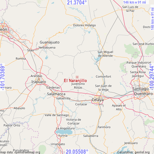
El Naranjillo GPS coordinates[2]
20° 42' 51.012" North, 101° 0' 2.016" West
| Map corner | latitude | longitude |
|---|---|---|
| Upper-left | 21.3704°, | -101.70369° |
| Center: | 20.71417°, | -101.00056° |
| Lower-right: | 20.05508°, | -100.29744° |
| Map W x H: | 146.2×146.3 km | = 90.8×90.9mi |
| max Lat: | 32.7° ⇑28.1% North |
| El Naranjillo: | 20.71417° |
| min Lat: | ⇓71.9% South 14.53588° |
| min Long | El Naranjillo | max Long |
| -117.105° | -101.00056° | -86.73105° |
| W 26.5%⇐ | ⇒73.5% E |
Elevation
Elevation of El Naranjillo is 1855 m = 6086 ft, and this is 601.3 m = 1973 ft above average elevation for this country.
| Max E: |
3497 m = 11473 ft | 33.8% |
| El Naranjillo | 1855 m 6086 ft | |
| Avg. | 1253.7 m = 4113 ft | |
Min E: |
-1 m = -3 ft | 66.2% |
See also: Mexico elevation on elevation.city.
Geographical zone
El Naranjillo is located in North Torrid zone (between Equator and Tropic of Cancer). Distance of this Northern Tropic circle is 302.7 km =188.1 mi to North.| Distance of | km | miles | from El Naranjillo |
|---|---|---|---|
| North Pole | 7703.9 | 4787 | to North |
| Arctic Circle | 5098 | 3167.7 | to North |
| Tropic Cancer | 302.7 | 188.1 | to North |
| Equator | 2303.2 | 1431.1 | to South |


Nearby cities:
15 places around El Naranjillo: (largest is in red/bold)
• Barrón
9.7 km =6 mi,  244°
244°
• Cañada del Agua
8.8 km =5.5 mi,  98°
98°
• Delgado de Arriba
10.4 km =6.5 mi,  85°
85°
• Don Diego
10.4 km =6.5 mi, 100°
• El Jaralillo
6 km =3.7 mi,  156°
156°
• El Murciélago
2.9 km =1.8 mi,  134°
134°
• Juventino Rosas
7.9 km =4.9 mi,  174°
174°
• La Purísima
10.5 km =6.5 mi,  208°
208°
• Los Dulces Nombres
8.2 km =5.1 mi,  153°
153°
• María Gómez
10.4 km =6.5 mi,  259°
259°
• Mesas de Acosta
8.8 km =5.5 mi,  296°
296°
• Pocitos de Corrales
5.9 km =3.7 mi,  83°
83°
• San Antonio de Corrales
5.2 km =3.2 mi,  47°
47°
• San Diego de los Dolores
3.2 km =2 mi,  294°
294°
• San José de las Pilas
8.3 km =5.2 mi, 214°
Sources, notices
• [Note1] Compared only with cities in Mexico existing in our database
• [Src1] Map data: © OpenStreetMap contributors (CC-BY-SA)
• [Src2] Other city data from geonames.org with taken over terms of usage.
• [Src3] Geographical zone / Annual Mean Temperature by Robert A. Rohde @ Wikipedia
