Mulegé geodata
Mulegé (Baja California Sur) is a populated place; located in Mexico in America/Mazatlan (GMT-7) time zone. With population of 3,851 people, there are 2379 cities with bigger population in this country. Compared to other cities in Mexico, 96.1% of cities are located further ↓South; 98.8% of cities are located further →East and 90% of cities have higher elevation than Mulegé. Note1


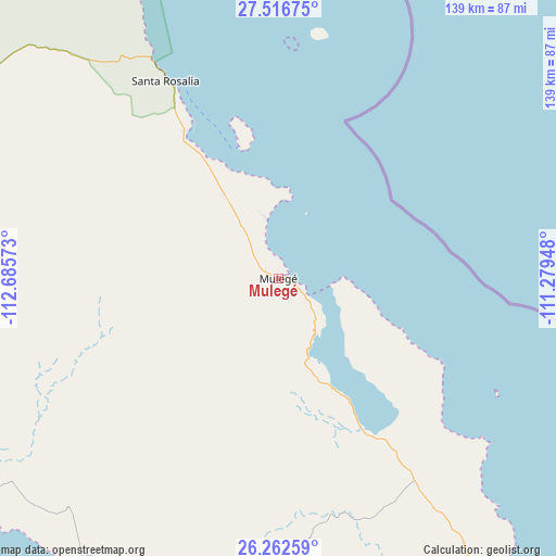
Mulegé GPS coordinates[2]
26° 53' 29.076" North, 111° 58' 57.36" West
| Map corner | latitude | longitude |
|---|---|---|
| Upper-left | 27.51675°, | -112.68573° |
| Center: | 26.89141°, | -111.9826° |
| Lower-right: | 26.26259°, | -111.27948° |
| Map W x H: | 139.4×139.5 km | = 86.6×86.7mi |
| max Lat: | 32.7° ⇑3.9% North |
| Mulegé: | 26.89141° |
| min Lat: | ⇓96.1% South 14.53588° |
| min Long | Mulegé | max Long |
| -117.105° | -111.9826° | -86.73105° |
| W 1.2%⇐ | ⇒98.8% E |
Elevation
Elevation of Mulegé is 24 m = 79 ft, and this is 1229.7 m = 4034 ft below average elevation for this country.
| Max E: |
3497 m = 11473 ft | 90% |
| Avg. | 1253.7 m = 4113 ft | |
| Mulegé | 24 m = 79 ft | |
Min E: |
-1 m = -3 ft | 10% |
See also: Mexico elevation on elevation.city.
Geographical zone
Mulegé is located in North temperate zone (between Tropic of Cancer and the Arctic Circle). Distance of this Northern Tropic circle is 384.1 km =238.7 mi to South.| Distance of | km | miles | from Mulegé |
|---|---|---|---|
| North Pole | 7017 | 4360.2 | to North |
| Arctic Circle | 4411.1 | 2740.9 | to North |
| Tropic Cancer | 384.1 | 238.7 | to South |
| Equator | 2990 | 1857.9 | to South |


Nearby cities:
15 places around Mulegé: (largest is in red/bold)
• Bahía de Lobos
159.6 km =99.2 mi,  71°
71°
• Ejido San Lucas
43.9 km =27.3 mi,  326°
326°
• El Silencio
145.2 km =90.2 mi,  296°
296°
• Heroica Guaymas
156.6 km =97.3 mi,  43°
43°
• Loreto
116.3 km =72.3 mi,  147°
147°
• Los Mártires Uno
132.5 km =82.3 mi,  292°
292°
• Punta Abreojos
159.2 km =98.9 mi,  262°
262°
• San Bruno
34.7 km =21.6 mi, 329°
• San Carlos
150.5 km =93.5 mi, 38°
• San Ignacio
100.4 km =62.4 mi, 295°
• San José de Guaymas
163.2 km =101.4 mi, 41°
• San Juanico
86.2 km =53.6 mi,  215°
215°
• Santa Rosalía
57.3 km =35.6 mi, 330°
• Valle Santo Domingo
156 km =96.9 mi,  177°
177°
• Villa Alberto Andrés Alvarado Arámburo
161.9 km =100.6 mi, 301°
Sources, notices
• [Note1] Compared only with cities in Mexico existing in our database
• [Src1] Map data: © OpenStreetMap contributors (CC-BY-SA)
• [Src2] Other city data from geonames.org with taken over terms of usage.
• [Src3] Geographical zone / Annual Mean Temperature by Robert A. Rohde @ Wikipedia
