El Castillo geodata
El Castillo (Jalisco) is a populated place; located in Mexico in America/Mexico_City (GMT-6) time zone. With population of 633 people, there are 13682 cities with bigger population in this country. Compared to other cities in Mexico, 64.9% of cities are located further ↓South; 82.1% of cities are located further →East and 54.9% of cities have lower elevation than El Castillo. Note1


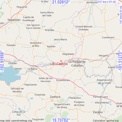
El Castillo GPS coordinates[2]
20° 22' 6.168" North, 102° 12' 57.06" West
| Map corner | latitude | longitude |
|---|---|---|
| Upper-left | 21.02612°, | -102.91898° |
| Center: | 20.36838°, | -102.21585° |
| Lower-right: | 19.70782°, | -101.51273° |
| Map W x H: | 146.6×146.6 km | = 91.1×91.1mi |
| max Lat: | 32.7° ⇑35.1% North |
| El Castillo: | 20.36838° |
| min Lat: | ⇓64.9% South 14.53588° |
| min Long | El Castillo | max Long |
| -117.105° | -102.21585° | -86.73105° |
| W 17.9%⇐ | ⇒82.1% E |
Elevation
Elevation of El Castillo is 1587 m = 5207 ft, and this is 333.3 m = 1094 ft above average elevation for this country.
| Max E: |
3497 m = 11473 ft | 45.1% |
| El Castillo | 1587 m 5207 ft | |
| Avg. | 1253.7 m = 4113 ft | |
Min E: |
-1 m = -3 ft | 54.9% |
See also: Mexico elevation on elevation.city.
Geographical zone
El Castillo is located in North Torrid zone (between Equator and Tropic of Cancer). Distance of this Northern Tropic circle is 341.2 km =212 mi to North.| Distance of | km | miles | from El Castillo |
|---|---|---|---|
| North Pole | 7742.3 | 4810.8 | to North |
| Arctic Circle | 5136.4 | 3191.6 | to North |
| Tropic Cancer | 341.2 | 212 | to North |
| Equator | 2264.8 | 1407.3 | to South |


Nearby cities:
15 places around El Castillo: (largest is in red/bold)
• Buenos Aires
4.5 km =2.8 mi,  68°
68°
• Degollado
13 km =8.1 mi,  32°
32°
• El Mezquite Grande
1.3 km =0.8 mi,  127°
127°
• El Refugio
10.1 km =6.3 mi,  189°
189°
• El Tequesquite
10.6 km =6.6 mi,  225°
225°
• Huáscato
12.8 km =8 mi,  344°
344°
• La Concepción
12 km =7.5 mi,  261°
261°
• La Noria
11.2 km =7 mi,  273°
273°
• La Ribera
7.3 km =4.5 mi,  252°
252°
• Las Cieneguitas
13.6 km =8.5 mi, 192°
• Mirandillas
8.1 km =5 mi,  140°
140°
• Monteleón
6.7 km =4.2 mi,  173°
173°
• San Jerónimo
13.3 km =8.3 mi,  284°
284°
• Santa Elena de la Cruz
13.4 km =8.3 mi, 282°
• Yurécuaro
7.9 km =4.9 mi,  243°
243°
Sources, notices
• [Note1] Compared only with cities in Mexico existing in our database
• [Src1] Map data: © OpenStreetMap contributors (CC-BY-SA)
• [Src2] Other city data from geonames.org with taken over terms of usage.
• [Src3] Geographical zone / Annual Mean Temperature by Robert A. Rohde @ Wikipedia
