Buenos Aires geodata
Buenos Aires (Jalisco) is a populated place; located in Mexico in America/Mexico_City (GMT-6) time zone. With population of 555 people, there are 15371 cities with bigger population in this country. Compared to other cities in Mexico, 65.3% of cities are located further ↓South; 81.9% of cities are located further →East and 56.2% of cities have lower elevation than Buenos Aires. Note1


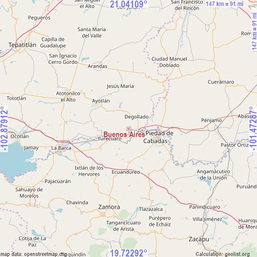
Buenos Aires GPS coordinates[2]
20° 23' 0.276" North, 102° 10' 33.564" West
| Map corner | latitude | longitude |
|---|---|---|
| Upper-left | 21.04109°, | -102.87912° |
| Center: | 20.38341°, | -102.17599° |
| Lower-right: | 19.72292°, | -101.47287° |
| Map W x H: | 146.6×146.6 km | = 91.1×91.1mi |
| max Lat: | 32.7° ⇑34.7% North |
| Buenos Aires: | 20.38341° |
| min Lat: | ⇓65.3% South 14.53588° |
| min Long | Buenos Aires | max Long |
| -117.105° | -102.17599° | -86.73105° |
| W 18.1%⇐ | ⇒81.9% E |
Elevation
Elevation of Buenos Aires is 1625 m = 5331 ft, and this is 371.3 m = 1218 ft above average elevation for this country.
| Max E: |
3497 m = 11473 ft | 43.8% |
| Buenos Aires | 1625 m 5331 ft | |
| Avg. | 1253.7 m = 4113 ft | |
Min E: |
-1 m = -3 ft | 56.2% |
See also: Mexico elevation on elevation.city.
Geographical zone
Buenos Aires is located in North Torrid zone (between Equator and Tropic of Cancer). Distance of this Northern Tropic circle is 339.5 km =211 mi to North.| Distance of | km | miles | from Buenos Aires |
|---|---|---|---|
| North Pole | 7740.6 | 4809.8 | to North |
| Arctic Circle | 5134.8 | 3190.6 | to North |
| Tropic Cancer | 339.5 | 211 | to North |
| Equator | 2266.4 | 1408.3 | to South |


Nearby cities:
15 places around Buenos Aires: (largest is in red/bold)
• Degollado
9.7 km =6 mi,  16°
16°
• El Castillo
4.5 km =2.8 mi,  248°
248°
• El Fuerte
11.4 km =7.1 mi,  96°
96°
• El Mezquite Grande
4 km =2.5 mi,  231°
231°
• El Refugio
13 km =8.1 mi,  206°
206°
• El Tequesquite
14.8 km =9.2 mi, 232°
• Huáscato
13.1 km =8.1 mi,  324°
324°
• La Noria
15.4 km =9.6 mi,  266°
266°
• La Piedad
15.8 km =9.8 mi,  106°
106°
• La Ribera
11.8 km =7.3 mi, 251°
• Los Fresnos
10.8 km =6.7 mi,  71°
71°
• Los Guajes
14.1 km =8.8 mi,  165°
165°
• Mirandillas
7.9 km =4.9 mi, 172°
• Monteleón
9 km =5.6 mi,  201°
201°
• Yurécuaro
12.4 km =7.7 mi,  244°
244°
Sources, notices
• [Note1] Compared only with cities in Mexico existing in our database
• [Src1] Map data: © OpenStreetMap contributors (CC-BY-SA)
• [Src2] Other city data from geonames.org with taken over terms of usage.
• [Src3] Geographical zone / Annual Mean Temperature by Robert A. Rohde @ Wikipedia
