Mirandillas geodata
Mirandillas (Jalisco) is a populated place; located in Mexico in America/Mexico_City (GMT-6) time zone. With population of 592 people, there are 14508 cities with bigger population in this country. Compared to other cities in Mexico, 68% of cities are located further ↓South; 83.5% of cities are located further →East and 55.3% of cities have lower elevation than Mirandillas. Note1


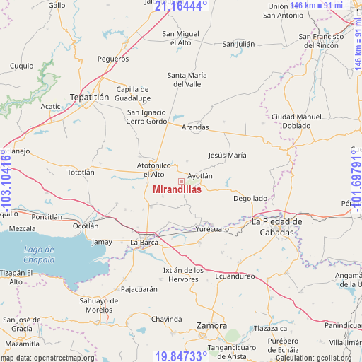
Mirandillas GPS coordinates[2]
20° 30' 26.28" North, 102° 24' 3.708" West
| Map corner | latitude | longitude |
|---|---|---|
| Upper-left | 21.16444°, | -103.10416° |
| Center: | 20.5073°, | -102.40103° |
| Lower-right: | 19.84733°, | -101.69791° |
| Map W x H: | 146.4×146.5 km | = 91×91mi |
| max Lat: | 32.7° ⇑32% North |
| Mirandillas: | 20.5073° |
| min Lat: | ⇓68% South 14.53588° |
| min Long | Mirandillas | max Long |
| -117.105° | -102.40103° | -86.73105° |
| W 16.5%⇐ | ⇒83.5% E |
Elevation
Elevation of Mirandillas is 1595 m = 5233 ft, and this is 341.3 m = 1120 ft above average elevation for this country.
| Max E: |
3497 m = 11473 ft | 44.7% |
| Mirandillas | 1595 m 5233 ft | |
| Avg. | 1253.7 m = 4113 ft | |
Min E: |
-1 m = -3 ft | 55.3% |
See also: Mexico elevation on elevation.city.
Geographical zone
Mirandillas is located in North Torrid zone (between Equator and Tropic of Cancer). Distance of this Northern Tropic circle is 325.7 km =202.4 mi to North.| Distance of | km | miles | from Mirandillas |
|---|---|---|---|
| North Pole | 7726.9 | 4801.3 | to North |
| Arctic Circle | 5121 | 3182 | to North |
| Tropic Cancer | 325.7 | 202.4 | to North |
| Equator | 2280.2 | 1416.9 | to South |


Nearby cities:
15 places around Mirandillas: (largest is in red/bold)
• Agua Caliente
6.3 km =3.9 mi,  255°
255°
• Atotonilco el Alto
12.3 km =7.6 mi,  293°
293°
• Ayotlán
8.2 km =5.1 mi,  72°
72°
• Betania
8.6 km =5.3 mi,  15°
15°
• Cañada de San Ignacio
7 km =4.3 mi,  44°
44°
• El Carmen
11.4 km =7.1 mi,  189°
189°
• El Maluco
11.3 km =7 mi,  116°
116°
• La Isla
5.9 km =3.7 mi,  112°
112°
• La Palma (La Angostura)
7.3 km =4.5 mi,  342°
342°
• Las Palmas
10.6 km =6.6 mi,  305°
305°
• Margaritas
9.7 km =6 mi,  231°
231°
• San Joaquín
10.7 km =6.6 mi, 255°
• San José Casas Caídas
10.4 km =6.5 mi,  203°
203°
• Santa Elena
10.9 km =6.8 mi,  246°
246°
• Santa Rita
7.4 km =4.6 mi,  171°
171°
Sources, notices
• [Note1] Compared only with cities in Mexico existing in our database
• [Src1] Map data: © OpenStreetMap contributors (CC-BY-SA)
• [Src2] Other city data from geonames.org with taken over terms of usage.
• [Src3] Geographical zone / Annual Mean Temperature by Robert A. Rohde @ Wikipedia
