La Isla geodata
La Isla (Jalisco) is a populated place; located in Mexico in America/Mexico_City (GMT-6) time zone. With population of 1,055 people, there are 8271 cities with bigger population in this country. Compared to other cities in Mexico, 67.5% of cities are located further ↓South; 83.2% of cities are located further →East and 54.8% of cities have lower elevation than La Isla. Note1


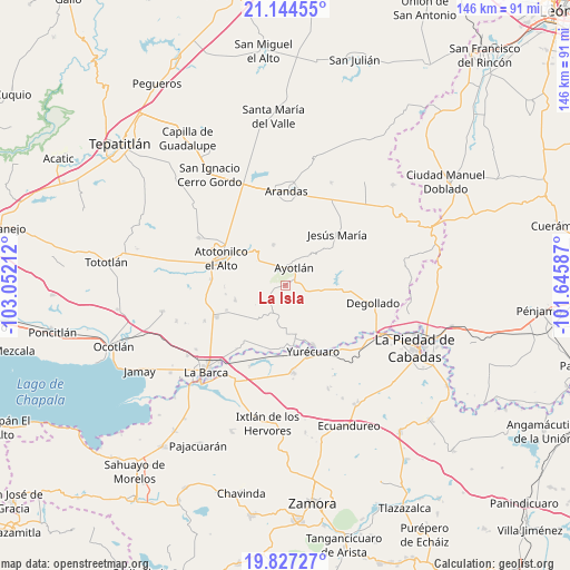
La Isla GPS coordinates[2]
20° 29' 14.352" North, 102° 20' 56.364" West
| Map corner | latitude | longitude |
|---|---|---|
| Upper-left | 21.14455°, | -103.05212° |
| Center: | 20.48732°, | -102.34899° |
| Lower-right: | 19.82727°, | -101.64587° |
| Map W x H: | 146.5×146.5 km | = 91×91mi |
| max Lat: | 32.7° ⇑32.5% North |
| La Isla: | 20.48732° |
| min Lat: | ⇓67.5% South 14.53588° |
| min Long | La Isla | max Long |
| -117.105° | -102.34899° | -86.73105° |
| W 16.8%⇐ | ⇒83.2% E |
Elevation
Elevation of La Isla is 1583 m = 5194 ft, and this is 329.3 m = 1080 ft above average elevation for this country.
| Max E: |
3497 m = 11473 ft | 45.2% |
| La Isla | 1583 m 5194 ft | |
| Avg. | 1253.7 m = 4113 ft | |
Min E: |
-1 m = -3 ft | 54.8% |
See also: Mexico elevation on elevation.city.
Geographical zone
La Isla is located in North Torrid zone (between Equator and Tropic of Cancer). Distance of this Northern Tropic circle is 327.9 km =203.7 mi to North.| Distance of | km | miles | from La Isla |
|---|---|---|---|
| North Pole | 7729.1 | 4802.6 | to North |
| Arctic Circle | 5123.2 | 3183.4 | to North |
| Tropic Cancer | 327.9 | 203.7 | to North |
| Equator | 2278 | 1415.5 | to South |


Nearby cities:
15 places around La Isla: (largest is in red/bold)
• Agua Caliente
11.6 km =7.2 mi,  273°
273°
• Ayotlán
5.2 km =3.2 mi,  27°
27°
• Betania
11 km =6.8 mi,  343°
343°
• Cañada de San Ignacio
7.2 km =4.5 mi,  356°
356°
• El Carmen
11.6 km =7.2 mi,  219°
219°
• El Maluco
5.5 km =3.4 mi,  121°
121°
• Huáscato
10.5 km =6.5 mi,  94°
94°
• La Noria
12.9 km =8 mi,  168°
168°
• La Palma (La Angostura)
12 km =7.5 mi,  320°
320°
• Margaritas
13.6 km =8.5 mi,  253°
253°
• Mirandillas
5.9 km =3.7 mi,  292°
292°
• San Jerónimo
9.9 km =6.2 mi, 174°
• San José Casas Caídas
12.1 km =7.5 mi,  232°
232°
• Santa Elena de la Cruz
10.4 km =6.5 mi,  175°
175°
• Santa Rita
6.7 km =4.2 mi, 220°
Sources, notices
• [Note1] Compared only with cities in Mexico existing in our database
• [Src1] Map data: © OpenStreetMap contributors (CC-BY-SA)
• [Src2] Other city data from geonames.org with taken over terms of usage.
• [Src3] Geographical zone / Annual Mean Temperature by Robert A. Rohde @ Wikipedia
