La Palma (La Angostura) geodata
La Palma (La Angostura) (Jalisco) is a populated place; located in Mexico in America/Mexico_City (GMT-6) time zone. With population of 668 people, there are 12987 cities with bigger population in this country. Compared to other cities in Mexico, 69.4% of cities are located further ↓South; 83.7% of cities are located further →East and 66.8% of cities have lower elevation than La Palma (La Angostura). Note1
Current local time in La Palma (La Angostura):
05:20 AM, WednesdayDifference from your time zone: hours


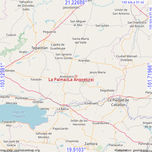
La Palma (La Angostura) GPS coordinates[2]
20° 34' 12" North, 102° 25' 22.008" West
| Map corner | latitude | longitude |
|---|---|---|
| Upper-left | 21.22686°, | -103.12591° |
| Center: | 20.57°, | -102.42278° |
| Lower-right: | 19.9103°, | -101.71966° |
| Map W x H: | 146.4×146.4 km | = 91×91mi |
| max Lat: | 32.7° ⇑30.6% North |
| La Palma (La Angostura): | 20.57° |
| min Lat: | ⇓69.4% South 14.53588° |
| min Long | La Palma (La An | max Long |
| -117.105° | -102.42278° | -86.73105° |
| W 16.3%⇐ | ⇒83.7% E |
Elevation
Elevation of La Palma (La Angostura) is 1865 m = 6119 ft, and this is 611.3 m = 2006 ft above average elevation for this country.
| Max E: |
3497 m = 11473 ft | 33.2% |
| La Palma (La Angostura) | 1865 m 6119 ft | |
| Avg. | 1253.7 m = 4113 ft | |
Min E: |
-1 m = -3 ft | 66.8% |
See also: Mexico elevation on elevation.city.
Geographical zone
La Palma (La Angostura) is located in North Torrid zone (between Equator and Tropic of Cancer). Distance of this Northern Tropic circle is 318.7 km =198 mi to North.| Distance of | km | miles | from La Palma (La Angostura) |
|---|---|---|---|
| North Pole | 7719.9 | 4796.9 | to North |
| Arctic Circle | 5114 | 3177.7 | to North |
| Tropic Cancer | 318.7 | 198 | to North |
| Equator | 2287.2 | 1421.2 | to South |


Nearby cities:
15 places around La Palma (La Angostura): (largest is in red/bold)
• Agua Caliente
9.3 km =5.8 mi,  204°
204°
• Atotonilco el Alto
9.3 km =5.8 mi,  256°
256°
• Ayotlán
11 km =6.8 mi,  114°
114°
• Betania
4.7 km =2.9 mi,  73°
73°
• Cañada de San Ignacio
7.5 km =4.7 mi, 105°
• El Nacimiento
13.8 km =8.6 mi, 255°
• La Isla
12 km =7.5 mi,  140°
140°
• La Trinidad
13.2 km =8.2 mi,  332°
332°
• Las Palmas
6.4 km =4 mi, 262°
• Milpillas
13.9 km =8.6 mi,  236°
236°
• Mirandillas
7.3 km =4.5 mi,  162°
162°
• Ojo de Agua de Morán
11.5 km =7.1 mi,  283°
283°
• San Joaquín
12.6 km =7.8 mi,  219°
219°
• Santa Elena
13.7 km =8.5 mi,  214°
214°
• Vistas del Maguey [Fraccionamiento]
11.5 km =7.1 mi,  245°
245°
Sources, notices
• [Note1] Compared only with cities in Mexico existing in our database
• [Src1] Map data: © OpenStreetMap contributors (CC-BY-SA)
• [Src2] Other city data from geonames.org with taken over terms of usage.
• [Src3] Geographical zone / Annual Mean Temperature by Robert A. Rohde @ Wikipedia
