Las Palmas geodata
Las Palmas (Jalisco) is a populated place; located in Mexico in America/Mexico_City (GMT-6) time zone. With population of 702 people, there are 12396 cities with bigger population in this country. Compared to other cities in Mexico, 69.2% of cities are located further ↓South; 84% of cities are located further →East and 55.7% of cities have lower elevation than Las Palmas. Note1


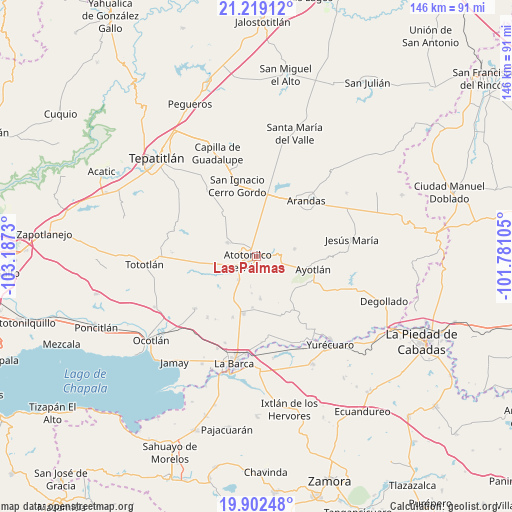
Las Palmas GPS coordinates[2]
20° 33' 43.992" North, 102° 29' 3.012" West
| Map corner | latitude | longitude |
|---|---|---|
| Upper-left | 21.21912°, | -103.1873° |
| Center: | 20.56222°, | -102.48417° |
| Lower-right: | 19.90248°, | -101.78105° |
| Map W x H: | 146.4×146.4 km | = 91×91mi |
| max Lat: | 32.7° ⇑30.8% North |
| Las Palmas: | 20.56222° |
| min Lat: | ⇓69.2% South 14.53588° |
| min Long | Las Palmas | max Long |
| -117.105° | -102.48417° | -86.73105° |
| W 16%⇐ | ⇒84% E |
Elevation
Elevation of Las Palmas is 1608 m = 5276 ft, and this is 354.3 m = 1162 ft above average elevation for this country.
| Max E: |
3497 m = 11473 ft | 44.3% |
| Las Palmas | 1608 m 5276 ft | |
| Avg. | 1253.7 m = 4113 ft | |
Min E: |
-1 m = -3 ft | 55.7% |
See also: Mexico elevation on elevation.city.
Geographical zone
Las Palmas is located in North Torrid zone (between Equator and Tropic of Cancer). Distance of this Northern Tropic circle is 319.6 km =198.6 mi to North.| Distance of | km | miles | from Las Palmas |
|---|---|---|---|
| North Pole | 7720.8 | 4797.5 | to North |
| Arctic Circle | 5114.9 | 3178.3 | to North |
| Tropic Cancer | 319.6 | 198.6 | to North |
| Equator | 2286.3 | 1420.6 | to South |


Nearby cities:
15 places around Las Palmas: (largest is in red/bold)
• Agua Caliente
8 km =5 mi,  161°
161°
• Atotonilco el Alto
2.9 km =1.8 mi,  244°
244°
• Betania
11.2 km =7 mi,  78°
78°
• Cucarachas
11.8 km =7.3 mi,  220°
220°
• El Nacimiento
7.5 km =4.7 mi,  249°
249°
• La Palma (La Angostura)
6.4 km =4 mi, 82°
• La Trinidad
12.6 km =7.8 mi,  1°
1°
• Margaritas
12.2 km =7.6 mi,  175°
175°
• Milpillas
8.6 km =5.3 mi, 217°
• Mirandillas
10.6 km =6.6 mi,  125°
125°
• Ojo de Agua de Morán
6 km =3.7 mi,  307°
307°
• San Francisco de Asís
9.1 km =5.7 mi,  295°
295°
• San Joaquín
9 km =5.6 mi,  190°
190°
• Santa Elena
10.6 km =6.6 mi, 187°
• Vistas del Maguey [Fraccionamiento]
5.6 km =3.5 mi,  227°
227°
Sources, notices
• [Note1] Compared only with cities in Mexico existing in our database
• [Src1] Map data: © OpenStreetMap contributors (CC-BY-SA)
• [Src2] Other city data from geonames.org with taken over terms of usage.
• [Src3] Geographical zone / Annual Mean Temperature by Robert A. Rohde @ Wikipedia
