Milpillas geodata
Milpillas (Jalisco) is a populated place; located in Mexico in America/Mexico_City (GMT-6) time zone. With population of 1,826 people, there are 4763 cities with bigger population in this country. Compared to other cities in Mexico, 67.8% of cities are located further ↓South; 84.2% of cities are located further →East and 54.2% of cities have lower elevation than Milpillas. Note1


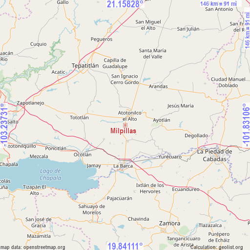
Milpillas GPS coordinates[2]
20° 30' 3.996" North, 102° 32' 3.048" West
| Map corner | latitude | longitude |
|---|---|---|
| Upper-left | 21.15828°, | -103.23731° |
| Center: | 20.50111°, | -102.53418° |
| Lower-right: | 19.84111°, | -101.83106° |
| Map W x H: | 146.5×146.5 km | = 91×91mi |
| max Lat: | 32.7° ⇑32.2% North |
| Milpillas: | 20.50111° |
| min Lat: | ⇓67.8% South 14.53588° |
| min Long | Milpillas | max Long |
| -117.105° | -102.53418° | -86.73105° |
| W 15.8%⇐ | ⇒84.2% E |
Elevation
Elevation of Milpillas is 1567 m = 5141 ft, and this is 313.3 m = 1028 ft above average elevation for this country.
| Max E: |
3497 m = 11473 ft | 45.8% |
| Milpillas | 1567 m 5141 ft | |
| Avg. | 1253.7 m = 4113 ft | |
Min E: |
-1 m = -3 ft | 54.2% |
See also: Mexico elevation on elevation.city.
Geographical zone
Milpillas is located in North Torrid zone (between Equator and Tropic of Cancer). Distance of this Northern Tropic circle is 326.4 km =202.8 mi to North.| Distance of | km | miles | from Milpillas |
|---|---|---|---|
| North Pole | 7727.6 | 4801.7 | to North |
| Arctic Circle | 5121.7 | 3182.5 | to North |
| Tropic Cancer | 326.4 | 202.8 | to North |
| Equator | 2279.5 | 1416.4 | to South |


Nearby cities:
15 places around Milpillas: (largest is in red/bold)
• Agua Caliente
7.8 km =4.8 mi,  96°
96°
• Atotonilco el Alto
6.1 km =3.8 mi,  25°
25°
• Cucarachas
3.3 km =2.1 mi,  228°
228°
• El Nacimiento
4.5 km =2.8 mi,  336°
336°
• Las Palmas
8.6 km =5.3 mi,  37°
37°
• Margaritas
8.2 km =5.1 mi,  130°
130°
• Nuevo Valle (Ex-Hacienda del Valle)
6.5 km =4 mi,  238°
238°
• Ojo de Agua de Morán
10.4 km =6.5 mi,  2°
2°
• Portezuelo
9.9 km =6.2 mi,  170°
170°
• San Antonio de Fernández
10.4 km =6.5 mi,  303°
303°
• San Joaquín
4.1 km =2.5 mi,  120°
120°
• San José del Valle
7 km =4.3 mi, 239°
• Santa Elena
5.4 km =3.4 mi, 133°
• Villa de García Márquez
8.8 km =5.5 mi,  152°
152°
• Vistas del Maguey [Fraccionamiento]
3.2 km =2 mi,  20°
20°
Sources, notices
• [Note1] Compared only with cities in Mexico existing in our database
• [Src1] Map data: © OpenStreetMap contributors (CC-BY-SA)
• [Src2] Other city data from geonames.org with taken over terms of usage.
• [Src3] Geographical zone / Annual Mean Temperature by Robert A. Rohde @ Wikipedia
