San Antonio de Fernández geodata
San Antonio de Fernández (Jalisco) is a populated place; located in Mexico in America/Mexico_City (GMT-6) time zone. With population of 1,326 people, there are 6543 cities with bigger population in this country. Compared to other cities in Mexico, 68.9% of cities are located further ↓South; 84.6% of cities are located further →East and 55.6% of cities have lower elevation than San Antonio de Fernández. Note1
Current local time in San Antonio de Fernández:
09:49 PM, TuesdayDifference from your time zone: hours


San Antonio de Fernández GPS coordinates[2]
20° 33' 6.696" North, 102° 37' 3.396" West
| Map corner | latitude | longitude |
|---|---|---|
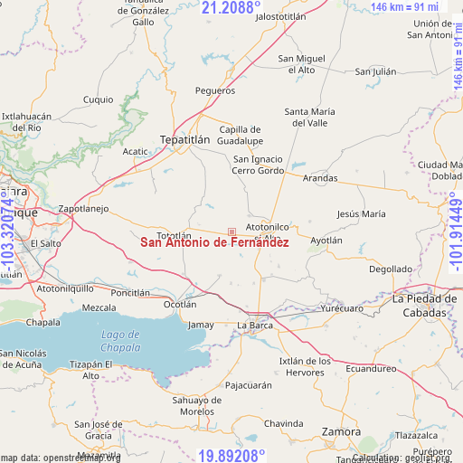
| Upper-left | 21.2088°, | -103.32074° |
| Center: | 20.55186°, | -102.61761° |
| Lower-right: | 19.89208°, | -101.91449° |
| Map W x H: | 146.4×146.4 km | = 91×91mi |
| max Lat: | 32.7° ⇑31.1% North |
| San Antonio de Fernández: | 20.55186° |
| min Lat: | ⇓68.9% South 14.53588° |
| min Long | San Antonio de | max Long |
| -117.105° | -102.61761° | -86.73105° |
| W 15.4%⇐ | ⇒84.6% E |
Elevation
Elevation of San Antonio de Fernández is 1606 m = 5269 ft, and this is 352.3 m = 1156 ft above average elevation for this country.
| Max E: |
3497 m = 11473 ft | 44.4% |
| San Antonio de Fernández | 1606 m 5269 ft | |
| Avg. | 1253.7 m = 4113 ft | |
Min E: |
-1 m = -3 ft | 55.6% |
See also: Mexico elevation on elevation.city.
Geographical zone
San Antonio de Fernández is located in North Torrid zone (between Equator and Tropic of Cancer). Distance of this Northern Tropic circle is 320.8 km =199.3 mi to North.| Distance of | km | miles | from San Antonio de Fernández |
|---|---|---|---|
| North Pole | 7721.9 | 4798.2 | to North |
| Arctic Circle | 5116 | 3178.9 | to North |
| Tropic Cancer | 320.8 | 199.3 | to North |
| Equator | 2285.2 | 1420 | to South |


Nearby cities:
15 places around San Antonio de Fernández: (largest is in red/bold)
• Atotonilco el Alto
11.3 km =7 mi,  90°
90°
• Coina Grande
13.4 km =8.3 mi,  256°
256°
• Cucarachas
10 km =6.2 mi,  141°
141°
• El Nacimiento
7.1 km =4.4 mi,  102°
102°
• Joconoxtle (La Tuna)
12.7 km =7.9 mi,  208°
208°
• Milpillas
10.4 km =6.5 mi,  123°
123°
• Nuevo Refugio de Afuera (Nuevo Refugio)
9.3 km =5.8 mi,  267°
267°
• Nuevo Valle (Ex-Hacienda del Valle)
9.5 km =5.9 mi,  160°
160°
• Ojo de Agua de Morán
10.3 km =6.4 mi,  62°
62°
• Rancho Viejo del Refugio
11.5 km =7.1 mi,  191°
191°
• San Agustín
13.6 km =8.5 mi,  311°
311°
• San Francisco de Asís
7.5 km =4.7 mi,  48°
48°
• San Isidro
10.5 km =6.5 mi,  282°
282°
• San José del Valle
9.6 km =6 mi, 163°
• Vistas del Maguey [Fraccionamiento]
10.2 km =6.3 mi,  105°
105°
Sources, notices
• [Note1] Compared only with cities in Mexico existing in our database
• [Src1] Map data: © OpenStreetMap contributors (CC-BY-SA)
• [Src2] Other city data from geonames.org with taken over terms of usage.
• [Src3] Geographical zone / Annual Mean Temperature by Robert A. Rohde @ Wikipedia
