Mesillas geodata
Mesillas (Aguascalientes) is a populated place; located in Mexico in America/Mexico_City (GMT-6) time zone. With population of 878 people, there are 9946 cities with bigger population in this country. Compared to other cities in Mexico, 85.8% of cities are located further ↓South; 81.8% of cities are located further →East and 73.5% of cities have lower elevation than Mesillas. Note1


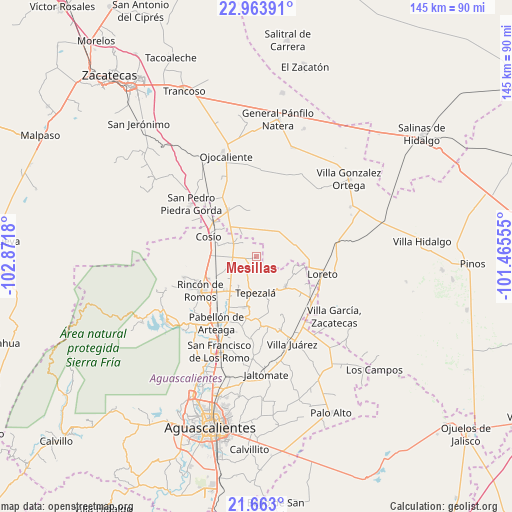
Mesillas GPS coordinates[2]
22° 18' 53.892" North, 102° 10' 7.212" West
| Map corner | latitude | longitude |
|---|---|---|
| Upper-left | 22.96391°, | -102.8718° |
| Center: | 22.31497°, | -102.16867° |
| Lower-right: | 21.663°, | -101.46555° |
| Map W x H: | 144.6×144.7 km | = 89.9×89.9mi |
| max Lat: | 32.7° ⇑14.2% North |
| Mesillas: | 22.31497° |
| min Lat: | ⇓85.8% South 14.53588° |
| min Long | Mesillas | max Long |
| -117.105° | -102.16867° | -86.73105° |
| W 18.2%⇐ | ⇒81.8% E |
Elevation
Elevation of Mesillas is 2000 m = 6562 ft, and this is 746.3 m = 2448 ft above average elevation for this country.
| Max E: |
3497 m = 11473 ft | 26.5% |
| Mesillas | 2000 m 6562 ft | |
| Avg. | 1253.7 m = 4113 ft | |
Min E: |
-1 m = -3 ft | 73.5% |
See also: Mexico elevation on elevation.city.
Geographical zone
Mesillas is located in North Torrid zone (between Equator and Tropic of Cancer). Distance of this Northern Tropic circle is 124.7 km =77.5 mi to North.| Distance of | km | miles | from Mesillas |
|---|---|---|---|
| North Pole | 7525.9 | 4676.4 | to North |
| Arctic Circle | 4920 | 3057.1 | to North |
| Tropic Cancer | 124.7 | 77.5 | to North |
| Equator | 2481.2 | 1541.7 | to South |


Nearby cities:
15 places around Mesillas: (largest is in red/bold)
• Asientos
11.8 km =7.3 mi,  136°
136°
• California
9.1 km =5.7 mi,  248°
248°
• El Chayote
7.9 km =4.9 mi, 246°
• El Porvenir
10.6 km =6.6 mi,  219°
219°
• El Refugio de Providencia (Providencia)
9.8 km =6.1 mi,  291°
291°
• El Valle de las Delicias
5.1 km =3.2 mi,  272°
272°
• Felipe Carrillo Puerto
6.8 km =4.2 mi,  101°
101°
• Jarillas
11 km =6.8 mi, 100°
• Los Alamitos
10.2 km =6.3 mi,  233°
233°
• Ojo de Agua de los Montes
3 km =1.9 mi, 232°
• Puerta del Muerto
8.5 km =5.3 mi,  255°
255°
• San Jacinto
7.7 km =4.8 mi,  299°
299°
• San Juan de la Natura
7.6 km =4.7 mi,  314°
314°
• Tepezalá
10.1 km =6.3 mi,  180°
180°
• Tierra Blanca
11.2 km =7 mi,  70°
70°
Sources, notices
• [Note1] Compared only with cities in Mexico existing in our database
• [Src1] Map data: © OpenStreetMap contributors (CC-BY-SA)
• [Src2] Other city data from geonames.org with taken over terms of usage.
• [Src3] Geographical zone / Annual Mean Temperature by Robert A. Rohde @ Wikipedia
